You are here: Home > Network List > CI - Caltech Regional Seismic Network Stations List
> Station MPM Manuel Prospect Mine, California, USA > Earthquake Result Viewer
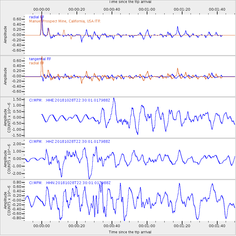
MPM Manuel Prospect Mine, California, USA - Earthquake Result Viewer
*The percent match for this event was below the threshold and hence no stack was calculated.
| Earthquake location: |
Off Coast Of Central America |
| Earthquake latitude/longitude: |
12.9/-90.4 |
| Earthquake time(UTC): |
2018/10/28 (301) 22:23:54 GMT |
| Earthquake Depth: |
25 km |
| Earthquake Magnitude: |
6.1 Mww |
| Earthquake Catalog/Contributor: |
NEIC PDE/us |
|
| Network: |
CI Caltech Regional Seismic Network |
| Station: |
MPM Manuel Prospect Mine, California, USA |
| Lat/Lon: |
36.06 N/117.49 W |
| Elevation: |
185 m |
|
| Distance: |
33.5 deg |
| Az: |
318.048 deg |
| Baz: |
126.457 deg |
| Ray Param: |
$rayparam |
*The percent match for this event was below the threshold and hence was not used in the summary stack. |
|
| Radial Match: |
79.38655 % |
| Radial Bump: |
400 |
| Transverse Match: |
66.51523 % |
| Transverse Bump: |
400 |
| SOD ConfigId: |
13570011 |
| Insert Time: |
2019-05-01 15:53:48.717 +0000 |
| GWidth: |
2.5 |
| Max Bumps: |
400 |
| Tol: |
0.001 |
|
Signal To Noise
| Channel | StoN | STA | LTA |
| CI:MPM: :HHZ:20181028T22:30:01.017988Z | 1.8236953 | 5.1228966E-7 | 2.809075E-7 |
| CI:MPM: :HHN:20181028T22:30:01.017988Z | 1.9552351 | 2.838626E-7 | 1.4518079E-7 |
| CI:MPM: :HHE:20181028T22:30:01.017988Z | 1.9617536 | 3.5693645E-7 | 1.8194764E-7 |
| Arrivals |
| Ps | |
| PpPs | |
| PsPs/PpSs | |


