You are here: Home > Network List > TA - USArray Transportable Network (new EarthScope stations) Stations List
> Station X21A Alamocita Creek, Datil, NM, USA > Earthquake Result Viewer
X21A Alamocita Creek, Datil, NM, USA - Earthquake Result Viewer

| Earthquake location: |
Andreanof Islands, Aleutian Is. |
| Earthquake latitude/longitude: |
52.2/-178.7 |
| Earthquake time(UTC): |
2008/03/22 (082) 21:24:11 GMT |
| Earthquake Depth: |
132 km |
| Earthquake Magnitude: |
5.8 MB, 6.2 MW, 6.1 MW |
| Earthquake Catalog/Contributor: |
WHDF/NEIC |
|
| Network: |
TA USArray Transportable Network (new EarthScope stations) |
| Station: |
X21A Alamocita Creek, Datil, NM, USA |
| Lat/Lon: |
34.45 N/107.79 W |
| Elevation: |
2141 m |
|
| Distance: |
52.4 deg |
| Az: |
80.266 deg |
| Baz: |
312.742 deg |
| Ray Param: |
0.06633362 |
| Estimated Moho Depth: |
19.0 km |
| Estimated Crust Vp/Vs: |
2.10 |
| Assumed Crust Vp: |
6.502 km/s |
| Estimated Crust Vs: |
3.1 km/s |
| Estimated Crust Poisson's Ratio: |
0.35 |
|
| Radial Match: |
97.003494 % |
| Radial Bump: |
363 |
| Transverse Match: |
91.74277 % |
| Transverse Bump: |
400 |
| SOD ConfigId: |
2564 |
| Insert Time: |
2010-03-06 17:15:16.302 +0000 |
| GWidth: |
2.5 |
| Max Bumps: |
400 |
| Tol: |
0.001 |
|
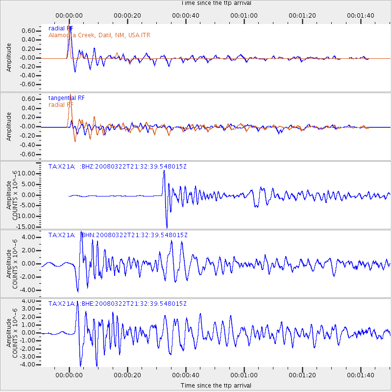
Signal To Noise
| Channel | StoN | STA | LTA |
| TA:X21A: :BHN:20080322T21:32:39.548015Z | 15.706719 | 2.2359056E-6 | 1.4235346E-7 |
| TA:X21A: :BHE:20080322T21:32:39.548015Z | 14.961296 | 1.9480415E-6 | 1.302054E-7 |
| TA:X21A: :BHZ:20080322T21:32:39.548015Z | 40.746765 | 5.8718083E-6 | 1.441049E-7 |
| Arrivals |
| Ps | 3.4 SECOND |
| PpPs | 8.6 SECOND |
| PsPs/PpSs | 12 SECOND |


