You are here: Home > Network List > TA - USArray Transportable Network (new EarthScope stations) Stations List
> Station X21A Alamocita Creek, Datil, NM, USA > Earthquake Result Viewer
X21A Alamocita Creek, Datil, NM, USA - Earthquake Result Viewer
| Earthquake location: |
Santa Cruz Islands Region |
| Earthquake latitude/longitude: |
-11.0/164.5 |
| Earthquake time(UTC): |
2008/07/19 (201) 09:27:01 GMT |
| Earthquake Depth: |
11 km |
| Earthquake Magnitude: |
6.1 MB, 6.4 MS, 6.6 MW, 6.6 MW |
| Earthquake Catalog/Contributor: |
WHDF/NEIC |
|
| Network: |
TA USArray Transportable Network (new EarthScope stations) |
| Station: |
X21A Alamocita Creek, Datil, NM, USA |
| Lat/Lon: |
34.45 N/107.79 W |
| Elevation: |
2141 m |
|
| Distance: |
94.3 deg |
| Az: |
55.904 deg |
| Baz: |
259.646 deg |
| Ray Param: |
0.04107669 |
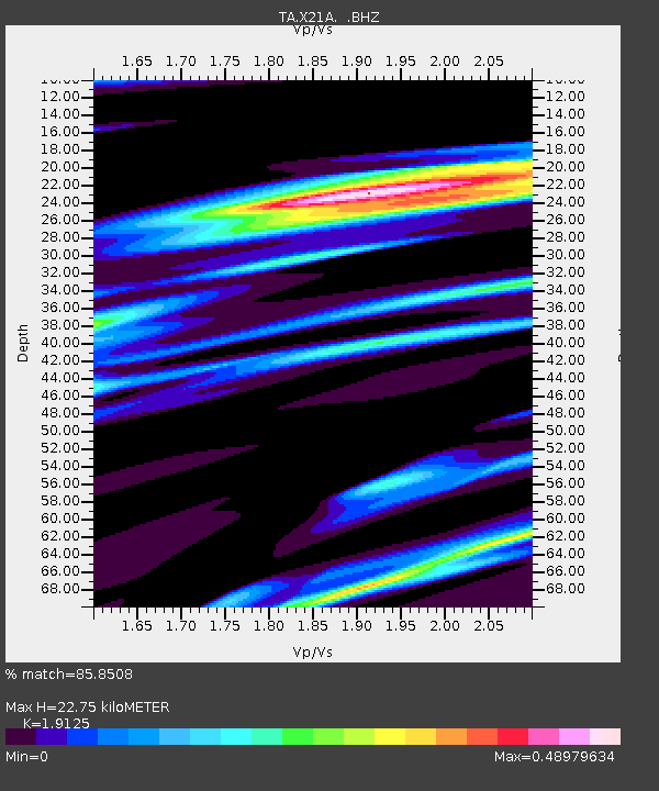
| Estimated Moho Depth: |
22.75 km |
| Estimated Crust Vp/Vs: |
1.91 |
| Assumed Crust Vp: |
6.502 km/s |
| Estimated Crust Vs: |
3.399 km/s |
| Estimated Crust Poisson's Ratio: |
0.31 |
|
| Radial Match: |
85.8508 % |
| Radial Bump: |
400 |
| Transverse Match: |
65.942085 % |
| Transverse Bump: |
400 |
| SOD ConfigId: |
2658 |
| Insert Time: |
2010-03-06 17:15:18.000 +0000 |
| GWidth: |
2.5 |
| Max Bumps: |
400 |
| Tol: |
0.001 |
|

Signal To Noise
| Channel | StoN | STA | LTA |
| TA:X21A: :BHZ:20080719T09:39:49.074014Z | 10.092992 | 7.50533E-7 | 7.43618E-8 |
| TA:X21A: :BHN:20080719T09:39:49.074014Z | 0.71795475 | 6.692899E-8 | 9.322174E-8 |
| TA:X21A: :BHE:20080719T09:39:49.074014Z | 3.5243464 | 2.4287067E-7 | 6.891226E-8 |
| Arrivals |
| Ps | 3.3 SECOND |
| PpPs | 10.0 SECOND |
| PsPs/PpSs | 13 SECOND |


