You are here: Home > Network List > TA - USArray Transportable Network (new EarthScope stations) Stations List
> Station X21A Alamocita Creek, Datil, NM, USA > Earthquake Result Viewer
X21A Alamocita Creek, Datil, NM, USA - Earthquake Result Viewer
| Earthquake location: |
Arctic Ocean |
| Earthquake latitude/longitude: |
79.6/-116.1 |
| Earthquake time(UTC): |
2008/11/17 (322) 12:55:22 GMT |
| Earthquake Depth: |
7.0 km |
| Earthquake Magnitude: |
5.7 MW, 5.2 MS, 5.4 MB, 5.7 MW |
| Earthquake Catalog/Contributor: |
WHDF/NEIC |
|
| Network: |
TA USArray Transportable Network (new EarthScope stations) |
| Station: |
X21A Alamocita Creek, Datil, NM, USA |
| Lat/Lon: |
34.45 N/107.79 W |
| Elevation: |
2141 m |
|
| Distance: |
45.4 deg |
| Az: |
170.396 deg |
| Baz: |
357.907 deg |
| Ray Param: |
0.07128592 |
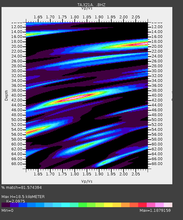
| Estimated Moho Depth: |
18.5 km |
| Estimated Crust Vp/Vs: |
2.10 |
| Assumed Crust Vp: |
6.502 km/s |
| Estimated Crust Vs: |
3.1 km/s |
| Estimated Crust Poisson's Ratio: |
0.35 |
|
| Radial Match: |
81.574394 % |
| Radial Bump: |
346 |
| Transverse Match: |
70.60873 % |
| Transverse Bump: |
400 |
| SOD ConfigId: |
2658 |
| Insert Time: |
2010-03-06 17:15:28.132 +0000 |
| GWidth: |
2.5 |
| Max Bumps: |
400 |
| Tol: |
0.001 |
|

Signal To Noise
| Channel | StoN | STA | LTA |
| TA:X21A: :BHZ:20081117T13:03:11.30001Z | 2.2031589 | 2.499299E-7 | 1.1344162E-7 |
| TA:X21A: :BHN:20081117T13:03:11.30001Z | 1.2706853 | 2.0690533E-7 | 1.6282972E-7 |
| TA:X21A: :BHE:20081117T13:03:11.30001Z | 0.7271036 | 1.1522223E-7 | 1.5846742E-7 |
| Arrivals |
| Ps | 3.3 SECOND |
| PpPs | 8.3 SECOND |
| PsPs/PpSs | 12 SECOND |


