You are here: Home > Network List > US - United States National Seismic Network Stations List
> Station SDCO Great Sand Dunes National Park, Colorado, USA > Earthquake Result Viewer
SDCO Great Sand Dunes National Park, Colorado, USA - Earthquake Result Viewer

| Earthquake location: |
Southeast Of Loyalty Islands |
| Earthquake latitude/longitude: |
-22.5/173.1 |
| Earthquake time(UTC): |
2016/08/12 (225) 01:26:35 GMT |
| Earthquake Depth: |
10 km |
| Earthquake Magnitude: |
7.2 MWW, 7.6 MI |
| Earthquake Catalog/Contributor: |
NEIC PDE/NEIC COMCAT |
|
| Network: |
US United States National Seismic Network |
| Station: |
SDCO Great Sand Dunes National Park, Colorado, USA |
| Lat/Lon: |
37.75 N/105.50 W |
| Elevation: |
2569 m |
|
| Distance: |
97.0 deg |
| Az: |
52.157 deg |
| Baz: |
247.114 deg |
| Ray Param: |
0.040342152 |
| Estimated Moho Depth: |
56.25 km |
| Estimated Crust Vp/Vs: |
1.61 |
| Assumed Crust Vp: |
6.316 km/s |
| Estimated Crust Vs: |
3.923 km/s |
| Estimated Crust Poisson's Ratio: |
0.19 |
|
| Radial Match: |
95.59171 % |
| Radial Bump: |
238 |
| Transverse Match: |
86.20235 % |
| Transverse Bump: |
361 |
| SOD ConfigId: |
1634031 |
| Insert Time: |
2016-08-26 01:29:39.900 +0000 |
| GWidth: |
2.5 |
| Max Bumps: |
400 |
| Tol: |
0.001 |
|
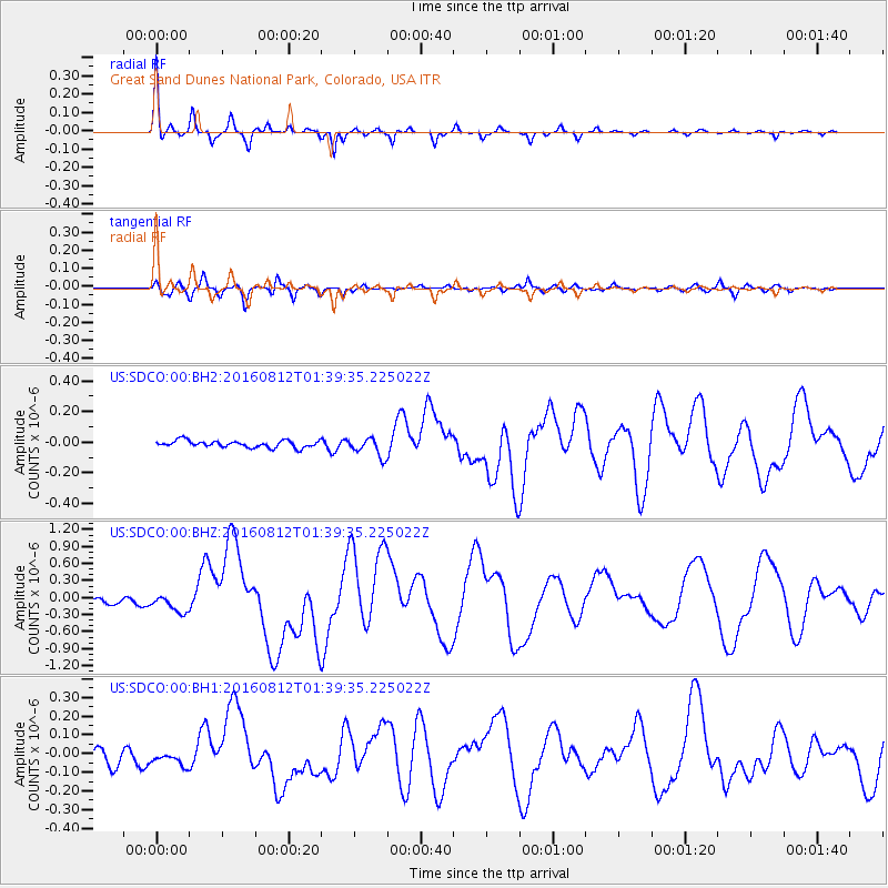
Signal To Noise
| Channel | StoN | STA | LTA |
| US:SDCO:00:BHZ:20160812T01:39:35.225022Z | 3.352391 | 1.5462268E-7 | 4.6123105E-8 |
| US:SDCO:00:BH1:20160812T01:39:35.225022Z | 0.6780588 | 2.9948488E-8 | 4.416798E-8 |
| US:SDCO:00:BH2:20160812T01:39:35.225022Z | 2.724124 | 6.076915E-8 | 2.2307777E-8 |
| Arrivals |
| Ps | 5.5 SECOND |
| PpPs | 23 SECOND |
| PsPs/PpSs | 28 SECOND |


