You are here: Home > Network List > US - United States National Seismic Network Stations List
> Station TPNV Topopah Spring, Nevada, USA > Earthquake Result Viewer
TPNV Topopah Spring, Nevada, USA - Earthquake Result Viewer
| Earthquake location: |
Southeast Of Loyalty Islands |
| Earthquake latitude/longitude: |
-22.5/173.1 |
| Earthquake time(UTC): |
2016/08/12 (225) 01:26:35 GMT |
| Earthquake Depth: |
10 km |
| Earthquake Magnitude: |
7.2 MWW, 7.6 MI |
| Earthquake Catalog/Contributor: |
NEIC PDE/NEIC COMCAT |
|
| Network: |
US United States National Seismic Network |
| Station: |
TPNV Topopah Spring, Nevada, USA |
| Lat/Lon: |
36.95 N/116.25 W |
| Elevation: |
1600 m |
|
| Distance: |
89.0 deg |
| Az: |
49.106 deg |
| Baz: |
240.769 deg |
| Ray Param: |
0.042189118 |
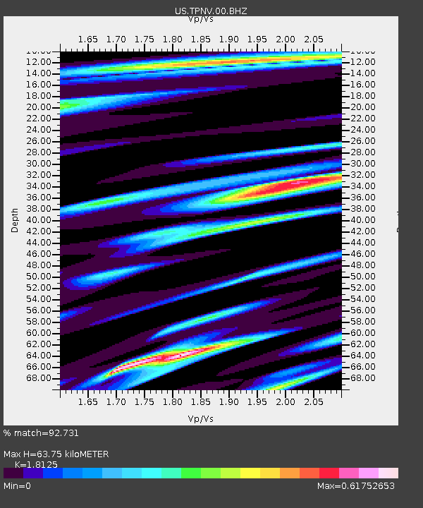
| Estimated Moho Depth: |
63.75 km |
| Estimated Crust Vp/Vs: |
1.81 |
| Assumed Crust Vp: |
6.279 km/s |
| Estimated Crust Vs: |
3.464 km/s |
| Estimated Crust Poisson's Ratio: |
0.28 |
|
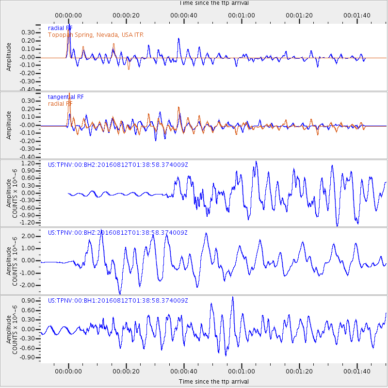
| Radial Match: |
92.731 % |
| Radial Bump: |
400 |
| Transverse Match: |
86.41226 % |
| Transverse Bump: |
400 |
| SOD ConfigId: |
1634031 |
| Insert Time: |
2016-08-26 01:29:41.246 +0000 |
| GWidth: |
2.5 |
| Max Bumps: |
400 |
| Tol: |
0.001 |
|
Signal To Noise
| Channel | StoN | STA | LTA |
| US:TPNV:00:BHZ:20160812T01:38:58.374009Z | 8.787809 | 2.1674694E-7 | 2.46645E-8 |
| US:TPNV:00:BH1:20160812T01:38:58.374009Z | 1.0796516 | 7.284797E-8 | 6.747359E-8 |
| US:TPNV:00:BH2:20160812T01:38:58.374009Z | 0.84038687 | 4.6780475E-8 | 5.5665403E-8 |
| Arrivals |
| Ps | 8.4 SECOND |
| PpPs | 28 SECOND |
| PsPs/PpSs | 36 SECOND |


