You are here: Home > Network List > TA - USArray Transportable Network (new EarthScope stations) Stations List
> Station X21A Alamocita Creek, Datil, NM, USA > Earthquake Result Viewer
X21A Alamocita Creek, Datil, NM, USA - Earthquake Result Viewer

| Earthquake location: |
Off Coast Of Costa Rica |
| Earthquake latitude/longitude: |
7.9/-85.6 |
| Earthquake time(UTC): |
2009/08/13 (225) 09:37:35 GMT |
| Earthquake Depth: |
10 km |
| Earthquake Magnitude: |
5.8 MW, 5.3 MB |
| Earthquake Catalog/Contributor: |
WHDF/NEIC |
|
| Network: |
TA USArray Transportable Network (new EarthScope stations) |
| Station: |
X21A Alamocita Creek, Datil, NM, USA |
| Lat/Lon: |
34.45 N/107.79 W |
| Elevation: |
2141 m |
|
| Distance: |
33.3 deg |
| Az: |
325.449 deg |
| Baz: |
137.176 deg |
| Ray Param: |
0.07825682 |
| Estimated Moho Depth: |
35.0 km |
| Estimated Crust Vp/Vs: |
1.61 |
| Assumed Crust Vp: |
6.502 km/s |
| Estimated Crust Vs: |
4.044 km/s |
| Estimated Crust Poisson's Ratio: |
0.18 |
|
| Radial Match: |
84.10748 % |
| Radial Bump: |
328 |
| Transverse Match: |
69.16051 % |
| Transverse Bump: |
336 |
| SOD ConfigId: |
2622 |
| Insert Time: |
2010-03-06 17:15:41.605 +0000 |
| GWidth: |
2.5 |
| Max Bumps: |
400 |
| Tol: |
0.001 |
|
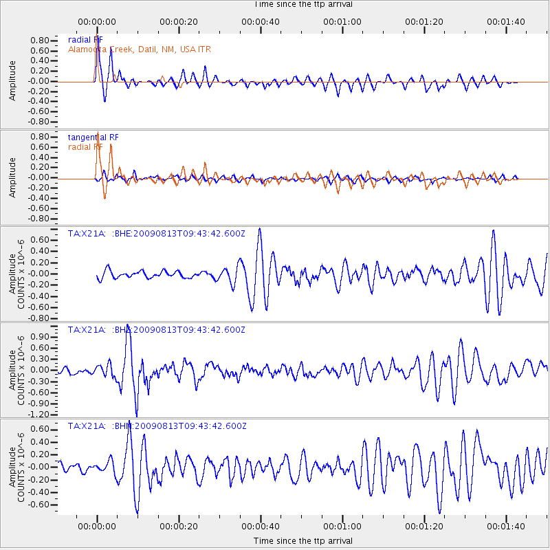
Signal To Noise
| Channel | StoN | STA | LTA |
| TA:X21A: :BHZ:20090813T09:43:42.600Z | 1.8854032 | 1.6449542E-7 | 8.724681E-8 |
| TA:X21A: :BHN:20090813T09:43:42.600Z | 1.8050259 | 9.892933E-8 | 5.4807707E-8 |
| TA:X21A: :BHE:20090813T09:43:42.600Z | 2.3745718 | 1.4500033E-7 | 6.106377E-8 |
| Arrivals |
| Ps | 3.6 SECOND |
| PpPs | 13 SECOND |
| PsPs/PpSs | 16 SECOND |


