You are here: Home > Network List > TA - USArray Transportable Network (new EarthScope stations) Stations List
> Station X21A Alamocita Creek, Datil, NM, USA > Earthquake Result Viewer
X21A Alamocita Creek, Datil, NM, USA - Earthquake Result Viewer
| Earthquake location: |
Tonga Islands |
| Earthquake latitude/longitude: |
-21.7/-174.6 |
| Earthquake time(UTC): |
2009/08/13 (225) 11:17:01 GMT |
| Earthquake Depth: |
10 km |
| Earthquake Magnitude: |
5.6 MW, 5.3 MB |
| Earthquake Catalog/Contributor: |
WHDF/NEIC |
|
| Network: |
TA USArray Transportable Network (new EarthScope stations) |
| Station: |
X21A Alamocita Creek, Datil, NM, USA |
| Lat/Lon: |
34.45 N/107.79 W |
| Elevation: |
2141 m |
|
| Distance: |
84.5 deg |
| Az: |
49.733 deg |
| Baz: |
239.19 deg |
| Ray Param: |
0.04546448 |
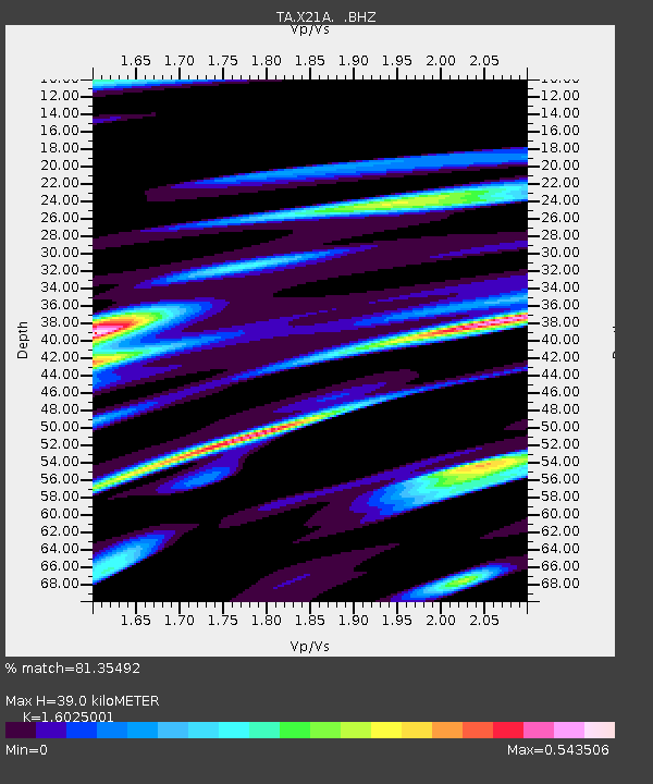
| Estimated Moho Depth: |
39.0 km |
| Estimated Crust Vp/Vs: |
1.60 |
| Assumed Crust Vp: |
6.502 km/s |
| Estimated Crust Vs: |
4.057 km/s |
| Estimated Crust Poisson's Ratio: |
0.18 |
|
| Radial Match: |
81.35492 % |
| Radial Bump: |
400 |
| Transverse Match: |
78.15421 % |
| Transverse Bump: |
400 |
| SOD ConfigId: |
2622 |
| Insert Time: |
2010-03-06 17:15:43.548 +0000 |
| GWidth: |
2.5 |
| Max Bumps: |
400 |
| Tol: |
0.001 |
|

Signal To Noise
| Channel | StoN | STA | LTA |
| TA:X21A: :BHZ:20090813T11:29:02.299011Z | 3.834689 | 1.9857484E-7 | 5.178382E-8 |
| TA:X21A: :BHN:20090813T11:29:02.299011Z | 0.8012453 | 4.1530377E-8 | 5.183229E-8 |
| TA:X21A: :BHE:20090813T11:29:02.299011Z | 1.2249299 | 6.793248E-8 | 5.545826E-8 |
| Arrivals |
| Ps | 3.7 SECOND |
| PpPs | 15 SECOND |
| PsPs/PpSs | 19 SECOND |


