You are here: Home > Network List > TA - USArray Transportable Network (new EarthScope stations) Stations List
> Station C18K Utukok River, AK, USA > Earthquake Result Viewer
C18K Utukok River, AK, USA - Earthquake Result Viewer
| Earthquake location: |
Off Coast Of Central America |
| Earthquake latitude/longitude: |
12.9/-90.4 |
| Earthquake time(UTC): |
2018/10/28 (301) 22:23:54 GMT |
| Earthquake Depth: |
25 km |
| Earthquake Magnitude: |
6.1 Mww |
| Earthquake Catalog/Contributor: |
NEIC PDE/us |
|
| Network: |
TA USArray Transportable Network (new EarthScope stations) |
| Station: |
C18K Utukok River, AK, USA |
| Lat/Lon: |
68.65 N/161.19 W |
| Elevation: |
845 m |
|
| Distance: |
71.1 deg |
| Az: |
338.552 deg |
| Baz: |
103.241 deg |
| Ray Param: |
0.0545386 |
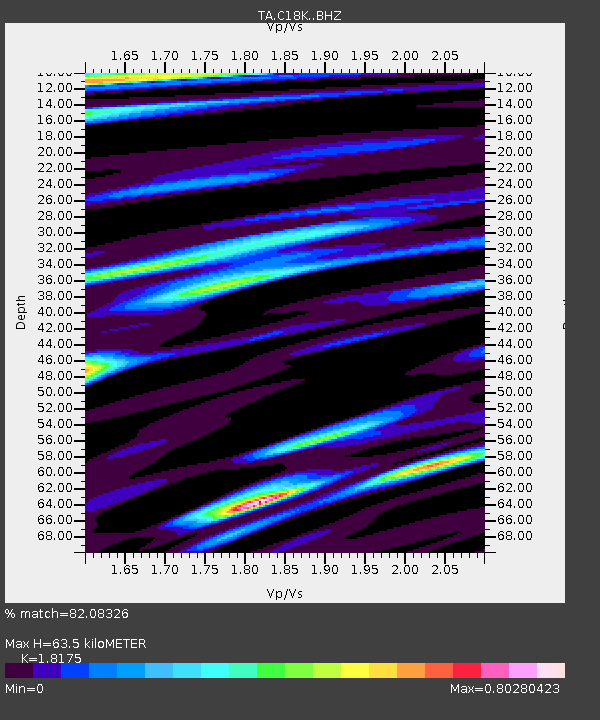
| Estimated Moho Depth: |
63.5 km |
| Estimated Crust Vp/Vs: |
1.82 |
| Assumed Crust Vp: |
5.906 km/s |
| Estimated Crust Vs: |
3.25 km/s |
| Estimated Crust Poisson's Ratio: |
0.28 |
|
| Radial Match: |
82.08326 % |
| Radial Bump: |
400 |
| Transverse Match: |
64.4035 % |
| Transverse Bump: |
400 |
| SOD ConfigId: |
13570011 |
| Insert Time: |
2019-05-01 15:57:17.442 +0000 |
| GWidth: |
2.5 |
| Max Bumps: |
400 |
| Tol: |
0.001 |
|

Signal To Noise
| Channel | StoN | STA | LTA |
| TA:C18K: :BHZ:20181028T22:34:38.85002Z | 3.0148346 | 5.332516E-7 | 1.7687589E-7 |
| TA:C18K: :BHN:20181028T22:34:38.85002Z | 2.161715 | 4.0503275E-7 | 1.873664E-7 |
| TA:C18K: :BHE:20181028T22:34:38.85002Z | 2.3085477 | 3.6384432E-7 | 1.5760745E-7 |
| Arrivals |
| Ps | 9.1 SECOND |
| PpPs | 29 SECOND |
| PsPs/PpSs | 38 SECOND |


