You are here: Home > Network List > TA - USArray Transportable Network (new EarthScope stations) Stations List
> Station X21A Alamocita Creek, Datil, NM, USA > Earthquake Result Viewer
X21A Alamocita Creek, Datil, NM, USA - Earthquake Result Viewer
| Earthquake location: |
Vanuatu Islands |
| Earthquake latitude/longitude: |
-13.0/166.5 |
| Earthquake time(UTC): |
2009/10/07 (280) 22:03:14 GMT |
| Earthquake Depth: |
45 km |
| Earthquake Magnitude: |
6.4 MB, 7.3 MS, 7.6 MW, 7.7 MW |
| Earthquake Catalog/Contributor: |
WHDF/NEIC |
|
| Network: |
TA USArray Transportable Network (new EarthScope stations) |
| Station: |
X21A Alamocita Creek, Datil, NM, USA |
| Lat/Lon: |
34.45 N/107.79 W |
| Elevation: |
2141 m |
|
| Distance: |
93.8 deg |
| Az: |
55.678 deg |
| Baz: |
256.915 deg |
| Ray Param: |
0.041178603 |
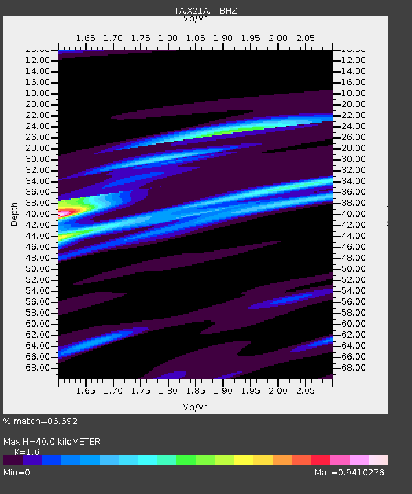
| Estimated Moho Depth: |
40.0 km |
| Estimated Crust Vp/Vs: |
1.60 |
| Assumed Crust Vp: |
6.502 km/s |
| Estimated Crust Vs: |
4.063 km/s |
| Estimated Crust Poisson's Ratio: |
0.18 |
|
| Radial Match: |
86.692 % |
| Radial Bump: |
314 |
| Transverse Match: |
62.21682 % |
| Transverse Bump: |
400 |
| SOD ConfigId: |
2622 |
| Insert Time: |
2010-03-06 17:15:57.626 +0000 |
| GWidth: |
2.5 |
| Max Bumps: |
400 |
| Tol: |
0.001 |
|

Signal To Noise
| Channel | StoN | STA | LTA |
| TA:X21A: :BHZ:20091007T22:15:55.250029Z | 4.7261486 | 9.795716E-7 | 2.0726635E-7 |
| TA:X21A: :BHN:20091007T22:15:55.250029Z | 0.30333328 | 1.6713798E-7 | 5.510044E-7 |
| TA:X21A: :BHE:20091007T22:15:55.250029Z | 1.3926277 | 5.920605E-7 | 4.2513912E-7 |
| Arrivals |
| Ps | 3.8 SECOND |
| PpPs | 16 SECOND |
| PsPs/PpSs | 19 SECOND |


