You are here: Home > Network List > TA - USArray Transportable Network (new EarthScope stations) Stations List
> Station X21A Alamocita Creek, Datil, NM, USA > Earthquake Result Viewer
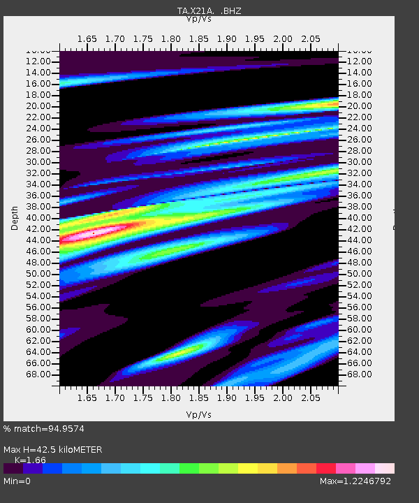
X21A Alamocita Creek, Datil, NM, USA - Earthquake Result Viewer
| Earthquake location: |
Fox Islands, Aleutian Islands |
| Earthquake latitude/longitude: |
52.6/-167.1 |
| Earthquake time(UTC): |
2009/10/13 (286) 20:21:53 GMT |
| Earthquake Depth: |
14 km |
| Earthquake Magnitude: |
5.9 MB, 6.4 MS, 6.4 MW, 6.4 MW |
| Earthquake Catalog/Contributor: |
WHDF/NEIC |
|
| Network: |
TA USArray Transportable Network (new EarthScope stations) |
| Station: |
X21A Alamocita Creek, Datil, NM, USA |
| Lat/Lon: |
34.45 N/107.79 W |
| Elevation: |
2141 m |
|
| Distance: |
45.3 deg |
| Az: |
89.247 deg |
| Baz: |
312.445 deg |
| Ray Param: |
0.071352676 |
| Estimated Moho Depth: |
42.5 km |
| Estimated Crust Vp/Vs: |
1.66 |
| Assumed Crust Vp: |
6.502 km/s |
| Estimated Crust Vs: |
3.917 km/s |
| Estimated Crust Poisson's Ratio: |
0.22 |
|
| Radial Match: |
94.9574 % |
| Radial Bump: |
399 |
| Transverse Match: |
83.79899 % |
| Transverse Bump: |
400 |
| SOD ConfigId: |
2622 |
| Insert Time: |
2010-03-06 17:16:03.919 +0000 |
| GWidth: |
2.5 |
| Max Bumps: |
400 |
| Tol: |
0.001 |
|

Signal To Noise
| Channel | StoN | STA | LTA |
| TA:X21A: :BHZ:20091013T20:29:39.575Z | 6.1195025 | 4.960872E-7 | 8.106659E-8 |
| TA:X21A: :BHN:20091013T20:29:39.575Z | 2.271202 | 3.8092298E-7 | 1.6771867E-7 |
| TA:X21A: :BHE:20091013T20:29:39.575Z | 2.8094685 | 3.362074E-7 | 1.196694E-7 |
| Arrivals |
| Ps | 4.6 SECOND |
| PpPs | 16 SECOND |
| PsPs/PpSs | 21 SECOND |


