You are here: Home > Network List > TA - USArray Transportable Network (new EarthScope stations) Stations List
> Station F15K North Star Ditch, AK, USA > Earthquake Result Viewer
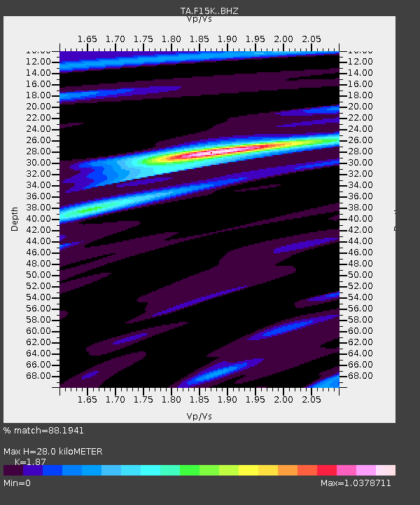
F15K North Star Ditch, AK, USA - Earthquake Result Viewer
| Earthquake location: |
Off Coast Of Central America |
| Earthquake latitude/longitude: |
12.9/-90.4 |
| Earthquake time(UTC): |
2018/10/28 (301) 22:23:54 GMT |
| Earthquake Depth: |
25 km |
| Earthquake Magnitude: |
6.1 Mww |
| Earthquake Catalog/Contributor: |
NEIC PDE/us |
|
| Network: |
TA USArray Transportable Network (new EarthScope stations) |
| Station: |
F15K North Star Ditch, AK, USA |
| Lat/Lon: |
65.71 N/164.65 W |
| Elevation: |
388 m |
|
| Distance: |
71.8 deg |
| Az: |
335.221 deg |
| Baz: |
98.999 deg |
| Ray Param: |
0.054045953 |
| Estimated Moho Depth: |
28.0 km |
| Estimated Crust Vp/Vs: |
1.87 |
| Assumed Crust Vp: |
6.276 km/s |
| Estimated Crust Vs: |
3.356 km/s |
| Estimated Crust Poisson's Ratio: |
0.30 |
|
| Radial Match: |
88.1941 % |
| Radial Bump: |
400 |
| Transverse Match: |
69.84225 % |
| Transverse Bump: |
400 |
| SOD ConfigId: |
13570011 |
| Insert Time: |
2019-05-01 15:57:38.944 +0000 |
| GWidth: |
2.5 |
| Max Bumps: |
400 |
| Tol: |
0.001 |
|

Signal To Noise
| Channel | StoN | STA | LTA |
| TA:F15K: :BHZ:20181028T22:34:43.374983Z | 4.9557567 | 6.0978044E-7 | 1.2304488E-7 |
| TA:F15K: :BHN:20181028T22:34:43.374983Z | 0.974205 | 1.2856482E-7 | 1.3196896E-7 |
| TA:F15K: :BHE:20181028T22:34:43.374983Z | 2.5121124 | 2.5630857E-7 | 1.020291E-7 |
| Arrivals |
| Ps | 4.0 SECOND |
| PpPs | 12 SECOND |
| PsPs/PpSs | 16 SECOND |


