You are here: Home > Network List > TA - USArray Transportable Network (new EarthScope stations) Stations List
> Station F21K Alatna River, AK, USA > Earthquake Result Viewer
F21K Alatna River, AK, USA - Earthquake Result Viewer
| Earthquake location: |
Off Coast Of Central America |
| Earthquake latitude/longitude: |
12.9/-90.4 |
| Earthquake time(UTC): |
2018/10/28 (301) 22:23:54 GMT |
| Earthquake Depth: |
25 km |
| Earthquake Magnitude: |
6.1 Mww |
| Earthquake Catalog/Contributor: |
NEIC PDE/us |
|
| Network: |
TA USArray Transportable Network (new EarthScope stations) |
| Station: |
F21K Alatna River, AK, USA |
| Lat/Lon: |
67.22 N/153.48 W |
| Elevation: |
597 m |
|
| Distance: |
67.9 deg |
| Az: |
337.983 deg |
| Baz: |
110.184 deg |
| Ray Param: |
0.056648612 |
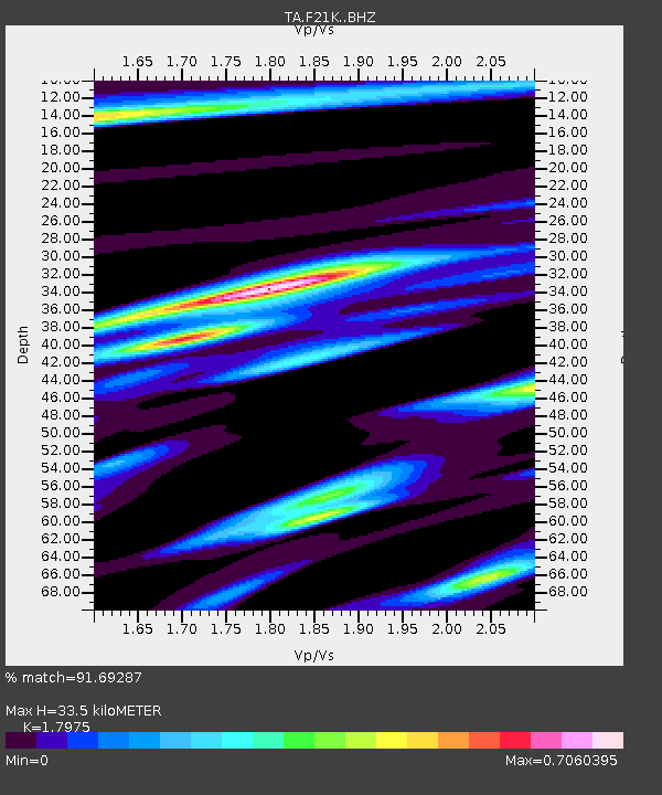
| Estimated Moho Depth: |
33.5 km |
| Estimated Crust Vp/Vs: |
1.80 |
| Assumed Crust Vp: |
6.455 km/s |
| Estimated Crust Vs: |
3.591 km/s |
| Estimated Crust Poisson's Ratio: |
0.28 |
|
| Radial Match: |
91.69287 % |
| Radial Bump: |
351 |
| Transverse Match: |
77.676094 % |
| Transverse Bump: |
400 |
| SOD ConfigId: |
13570011 |
| Insert Time: |
2019-05-01 15:57:43.347 +0000 |
| GWidth: |
2.5 |
| Max Bumps: |
400 |
| Tol: |
0.001 |
|
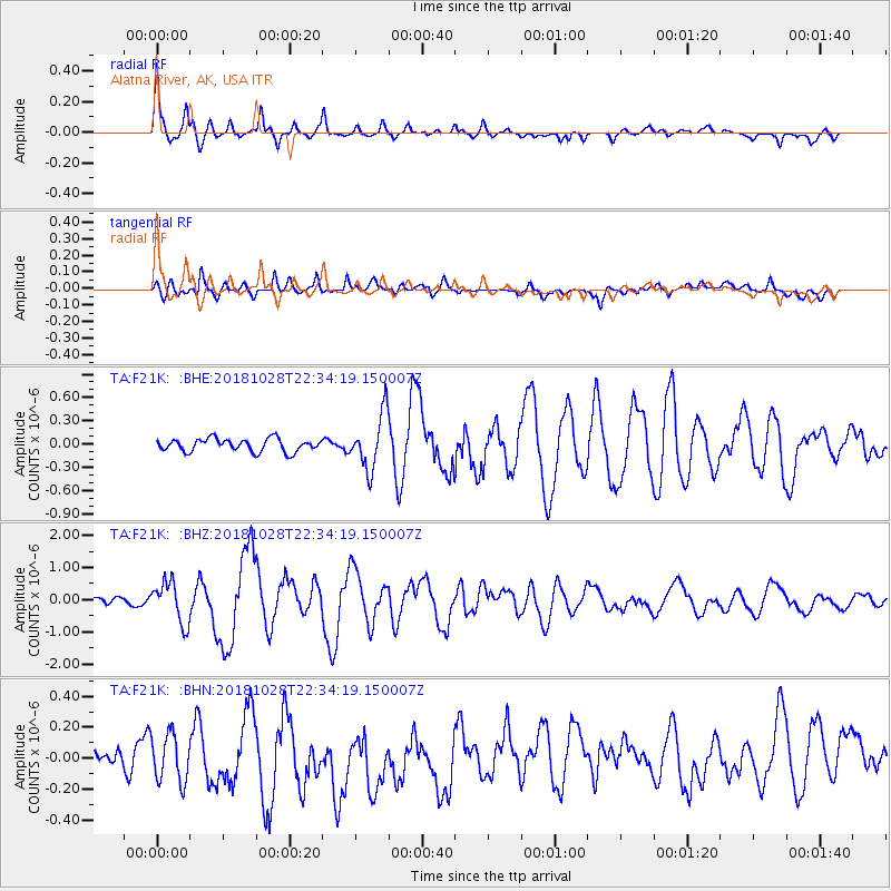
Signal To Noise
| Channel | StoN | STA | LTA |
| TA:F21K: :BHZ:20181028T22:34:19.150007Z | 4.891137 | 6.3913643E-7 | 1.3067236E-7 |
| TA:F21K: :BHN:20181028T22:34:19.150007Z | 2.1056354 | 1.5684799E-7 | 7.448963E-8 |
| TA:F21K: :BHE:20181028T22:34:19.150007Z | 4.3555307 | 3.5658903E-7 | 8.18704E-8 |
| Arrivals |
| Ps | 4.3 SECOND |
| PpPs | 14 SECOND |
| PsPs/PpSs | 18 SECOND |


