You are here: Home > Network List > TA - USArray Transportable Network (new EarthScope stations) Stations List
> Station X21A Alamocita Creek, Datil, NM, USA > Earthquake Result Viewer
X21A Alamocita Creek, Datil, NM, USA - Earthquake Result Viewer
| Earthquake location: |
Near East Coast Of Honshu, Japan |
| Earthquake latitude/longitude: |
35.5/140.9 |
| Earthquake time(UTC): |
2009/06/06 (157) 05:52:43 GMT |
| Earthquake Depth: |
34 km |
| Earthquake Magnitude: |
5.8 MB, 5.4 MS, 5.8 MW, 5.7 MW |
| Earthquake Catalog/Contributor: |
WHDF/NEIC |
|
| Network: |
TA USArray Transportable Network (new EarthScope stations) |
| Station: |
X21A Alamocita Creek, Datil, NM, USA |
| Lat/Lon: |
34.45 N/107.79 W |
| Elevation: |
2141 m |
|
| Distance: |
85.4 deg |
| Az: |
50.576 deg |
| Baz: |
310.285 deg |
| Ray Param: |
0.044753198 |
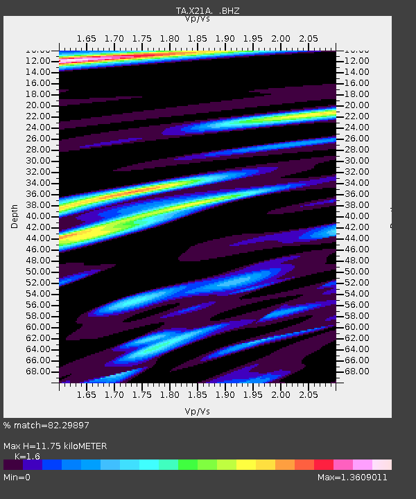
| Estimated Moho Depth: |
11.75 km |
| Estimated Crust Vp/Vs: |
1.60 |
| Assumed Crust Vp: |
6.502 km/s |
| Estimated Crust Vs: |
4.063 km/s |
| Estimated Crust Poisson's Ratio: |
0.18 |
|
| Radial Match: |
82.29897 % |
| Radial Bump: |
400 |
| Transverse Match: |
78.5556 % |
| Transverse Bump: |
400 |
| SOD ConfigId: |
2648 |
| Insert Time: |
2010-03-06 17:16:17.848 +0000 |
| GWidth: |
2.5 |
| Max Bumps: |
400 |
| Tol: |
0.001 |
|

Signal To Noise
| Channel | StoN | STA | LTA |
| TA:X21A: :BHZ:20090606T06:04:45.974011Z | 10.945989 | 5.6151464E-7 | 5.1298667E-8 |
| TA:X21A: :BHN:20090606T06:04:45.974011Z | 2.5894787 | 1.5918775E-7 | 6.147482E-8 |
| TA:X21A: :BHE:20090606T06:04:45.974011Z | 2.147721 | 1.577057E-7 | 7.342933E-8 |
| Arrivals |
| Ps | 1.1 SECOND |
| PpPs | 4.6 SECOND |
| PsPs/PpSs | 5.7 SECOND |


