You are here: Home > Network List > TA - USArray Transportable Network (new EarthScope stations) Stations List
> Station J26L Joseph Creek, AK, USA > Earthquake Result Viewer
J26L Joseph Creek, AK, USA - Earthquake Result Viewer
| Earthquake location: |
Off Coast Of Central America |
| Earthquake latitude/longitude: |
12.9/-90.4 |
| Earthquake time(UTC): |
2018/10/28 (301) 22:23:54 GMT |
| Earthquake Depth: |
25 km |
| Earthquake Magnitude: |
6.1 Mww |
| Earthquake Catalog/Contributor: |
NEIC PDE/us |
|
| Network: |
TA USArray Transportable Network (new EarthScope stations) |
| Station: |
J26L Joseph Creek, AK, USA |
| Lat/Lon: |
64.50 N/143.56 W |
| Elevation: |
1144 m |
|
| Distance: |
63.0 deg |
| Az: |
337.12 deg |
| Baz: |
118.873 deg |
| Ray Param: |
0.05981199 |
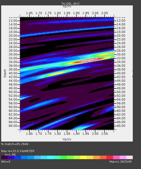
| Estimated Moho Depth: |
33.0 km |
| Estimated Crust Vp/Vs: |
1.96 |
| Assumed Crust Vp: |
6.566 km/s |
| Estimated Crust Vs: |
3.35 km/s |
| Estimated Crust Poisson's Ratio: |
0.32 |
|
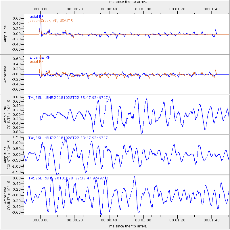
| Radial Match: |
85.2948 % |
| Radial Bump: |
400 |
| Transverse Match: |
54.61564 % |
| Transverse Bump: |
309 |
| SOD ConfigId: |
13570011 |
| Insert Time: |
2019-05-01 15:58:15.002 +0000 |
| GWidth: |
2.5 |
| Max Bumps: |
400 |
| Tol: |
0.001 |
|
Signal To Noise
| Channel | StoN | STA | LTA |
| TA:J26L: :BHZ:20181028T22:33:47.924971Z | 4.427764 | 7.5861556E-7 | 1.7133154E-7 |
| TA:J26L: :BHN:20181028T22:33:47.924971Z | 1.1283326 | 2.9906403E-7 | 2.6504955E-7 |
| TA:J26L: :BHE:20181028T22:33:47.924971Z | 3.61852 | 4.2079213E-7 | 1.1628846E-7 |
| Arrivals |
| Ps | 5.0 SECOND |
| PpPs | 14 SECOND |
| PsPs/PpSs | 19 SECOND |


