You are here: Home > Network List > TA - USArray Transportable Network (new EarthScope stations) Stations List
> Station N30M Aishikik Lake, Yukon, CAN > Earthquake Result Viewer
N30M Aishikik Lake, Yukon, CAN - Earthquake Result Viewer
| Earthquake location: |
Off Coast Of Central America |
| Earthquake latitude/longitude: |
12.9/-90.4 |
| Earthquake time(UTC): |
2018/10/28 (301) 22:23:54 GMT |
| Earthquake Depth: |
25 km |
| Earthquake Magnitude: |
6.1 Mww |
| Earthquake Catalog/Contributor: |
NEIC PDE/us |
|
| Network: |
TA USArray Transportable Network (new EarthScope stations) |
| Station: |
N30M Aishikik Lake, Yukon, CAN |
| Lat/Lon: |
61.46 N/137.09 W |
| Elevation: |
941 m |
|
| Distance: |
58.9 deg |
| Az: |
335.91 deg |
| Baz: |
124.049 deg |
| Ray Param: |
0.06250133 |
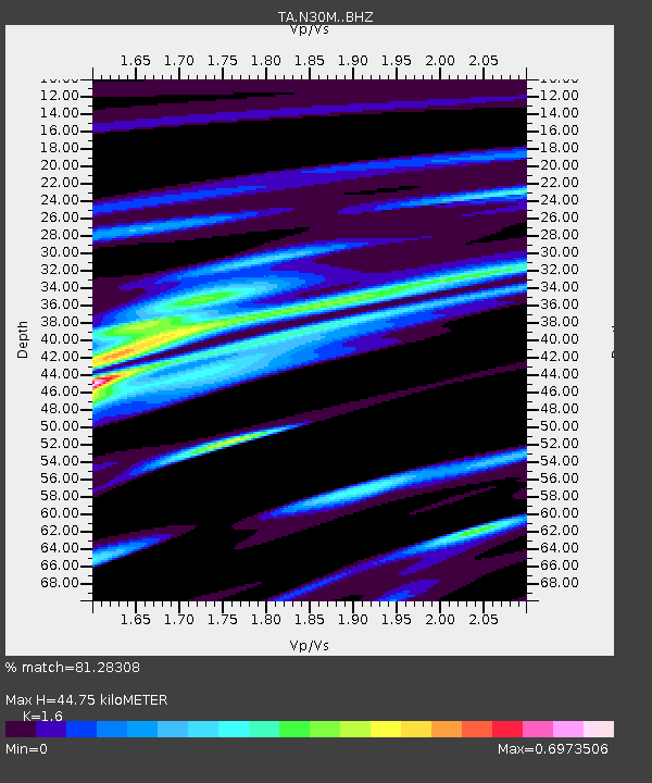
| Estimated Moho Depth: |
44.75 km |
| Estimated Crust Vp/Vs: |
1.60 |
| Assumed Crust Vp: |
6.566 km/s |
| Estimated Crust Vs: |
4.104 km/s |
| Estimated Crust Poisson's Ratio: |
0.18 |
|
| Radial Match: |
81.28308 % |
| Radial Bump: |
400 |
| Transverse Match: |
48.801224 % |
| Transverse Bump: |
398 |
| SOD ConfigId: |
13570011 |
| Insert Time: |
2019-05-01 15:58:35.628 +0000 |
| GWidth: |
2.5 |
| Max Bumps: |
400 |
| Tol: |
0.001 |
|

Signal To Noise
| Channel | StoN | STA | LTA |
| TA:N30M: :BHZ:20181028T22:33:20.049971Z | 1.6193271 | 6.21877E-7 | 3.8403422E-7 |
| TA:N30M: :BHN:20181028T22:33:20.049971Z | 0.8931583 | 2.2808315E-7 | 2.5536698E-7 |
| TA:N30M: :BHE:20181028T22:33:20.049971Z | 2.4951234 | 4.804282E-7 | 1.9254686E-7 |
| Arrivals |
| Ps | 4.3 SECOND |
| PpPs | 17 SECOND |
| PsPs/PpSs | 21 SECOND |


