You are here: Home > Network List > TA - USArray Transportable Network (new EarthScope stations) Stations List
> Station X21A Alamocita Creek, Datil, NM, USA > Earthquake Result Viewer
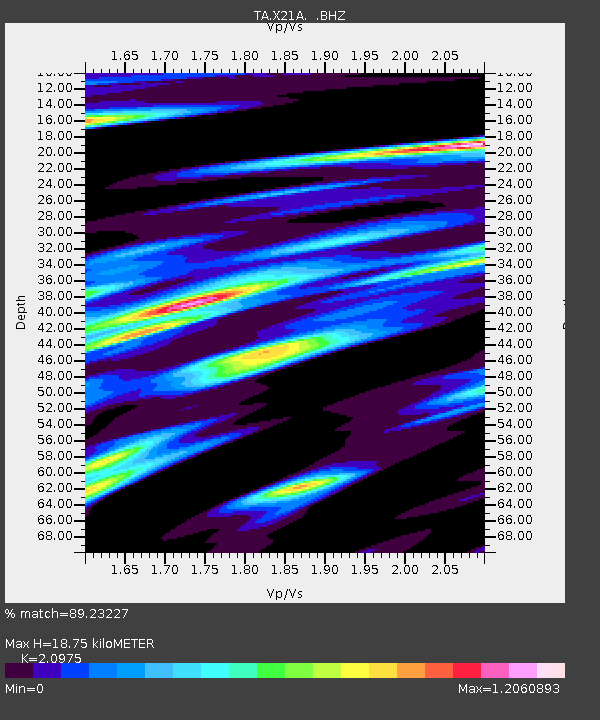
X21A Alamocita Creek, Datil, NM, USA - Earthquake Result Viewer
| Earthquake location: |
Rat Islands, Aleutian Islands |
| Earthquake latitude/longitude: |
50.4/177.0 |
| Earthquake time(UTC): |
2009/07/06 (187) 14:53:12 GMT |
| Earthquake Depth: |
22 km |
| Earthquake Magnitude: |
6.0 MB, 5.8 MS, 6.1 MW, 6.0 MW |
| Earthquake Catalog/Contributor: |
WHDF/NEIC |
|
| Network: |
TA USArray Transportable Network (new EarthScope stations) |
| Station: |
X21A Alamocita Creek, Datil, NM, USA |
| Lat/Lon: |
34.45 N/107.79 W |
| Elevation: |
2141 m |
|
| Distance: |
55.4 deg |
| Az: |
76.083 deg |
| Baz: |
311.315 deg |
| Ray Param: |
0.064780615 |
| Estimated Moho Depth: |
18.75 km |
| Estimated Crust Vp/Vs: |
2.10 |
| Assumed Crust Vp: |
6.502 km/s |
| Estimated Crust Vs: |
3.1 km/s |
| Estimated Crust Poisson's Ratio: |
0.35 |
|
| Radial Match: |
89.23227 % |
| Radial Bump: |
400 |
| Transverse Match: |
70.69807 % |
| Transverse Bump: |
400 |
| SOD ConfigId: |
2648 |
| Insert Time: |
2010-03-06 17:16:32.907 +0000 |
| GWidth: |
2.5 |
| Max Bumps: |
400 |
| Tol: |
0.001 |
|

Signal To Noise
| Channel | StoN | STA | LTA |
| TA:X21A: :BHZ:20090706T15:02:13.849009Z | 5.863742 | 2.1921026E-6 | 3.738402E-7 |
| TA:X21A: :BHN:20090706T15:02:13.849009Z | 2.2725759 | 1.0330382E-6 | 4.5456707E-7 |
| TA:X21A: :BHE:20090706T15:02:13.849009Z | 2.0346913 | 1.0034862E-6 | 4.931884E-7 |
| Arrivals |
| Ps | 3.3 SECOND |
| PpPs | 8.5 SECOND |
| PsPs/PpSs | 12 SECOND |


