You are here: Home > Network List > UU - University of Utah Regional Network Stations List
> Station LCMT Little Creek Mountain, UT, USA > Earthquake Result Viewer
LCMT Little Creek Mountain, UT, USA - Earthquake Result Viewer
| Earthquake location: |
Southeast Of Loyalty Islands |
| Earthquake latitude/longitude: |
-22.5/173.1 |
| Earthquake time(UTC): |
2016/08/12 (225) 01:26:35 GMT |
| Earthquake Depth: |
10 km |
| Earthquake Magnitude: |
7.2 MWW, 7.6 MI |
| Earthquake Catalog/Contributor: |
NEIC PDE/NEIC COMCAT |
|
| Network: |
UU University of Utah Regional Network |
| Station: |
LCMT Little Creek Mountain, UT, USA |
| Lat/Lon: |
37.01 N/113.24 W |
| Elevation: |
1411 m |
|
| Distance: |
91.1 deg |
| Az: |
50.193 deg |
| Baz: |
242.568 deg |
| Ray Param: |
0.04162464 |
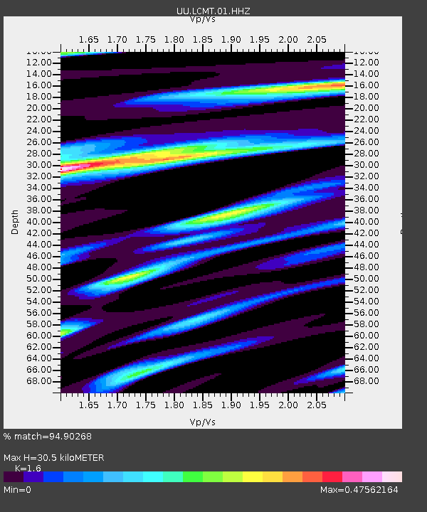
| Estimated Moho Depth: |
30.5 km |
| Estimated Crust Vp/Vs: |
1.60 |
| Assumed Crust Vp: |
6.194 km/s |
| Estimated Crust Vs: |
3.871 km/s |
| Estimated Crust Poisson's Ratio: |
0.18 |
|
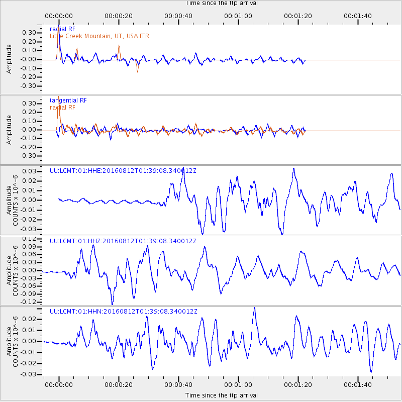
| Radial Match: |
94.90268 % |
| Radial Bump: |
329 |
| Transverse Match: |
83.691185 % |
| Transverse Bump: |
400 |
| SOD ConfigId: |
1634031 |
| Insert Time: |
2016-08-26 01:30:24.101 +0000 |
| GWidth: |
2.5 |
| Max Bumps: |
400 |
| Tol: |
0.001 |
|
Signal To Noise
| Channel | StoN | STA | LTA |
| UU:LCMT:01:HHZ:20160812T01:39:08.340012Z | 7.167164 | 9.561216E-9 | 1.3340306E-9 |
| UU:LCMT:01:HHN:20160812T01:39:08.340012Z | 1.5797734 | 1.5626248E-9 | 9.891449E-10 |
| UU:LCMT:01:HHE:20160812T01:39:08.340012Z | 1.6208566 | 2.2310758E-9 | 1.3764794E-9 |
| Arrivals |
| Ps | 3.0 SECOND |
| PpPs | 13 SECOND |
| PsPs/PpSs | 16 SECOND |


