You are here: Home > Network List > TA - USArray Transportable Network (new EarthScope stations) Stations List
> Station X21A Alamocita Creek, Datil, NM, USA > Earthquake Result Viewer
X21A Alamocita Creek, Datil, NM, USA - Earthquake Result Viewer
| Earthquake location: |
Kuril Islands |
| Earthquake latitude/longitude: |
45.4/151.0 |
| Earthquake time(UTC): |
2008/07/06 (188) 09:08:20 GMT |
| Earthquake Depth: |
10 km |
| Earthquake Magnitude: |
5.8 MB, 5.4 MS, 5.7 MW, 5.7 MW |
| Earthquake Catalog/Contributor: |
WHDF/NEIC |
|
| Network: |
TA USArray Transportable Network (new EarthScope stations) |
| Station: |
X21A Alamocita Creek, Datil, NM, USA |
| Lat/Lon: |
34.45 N/107.79 W |
| Elevation: |
2141 m |
|
| Distance: |
73.4 deg |
| Az: |
57.759 deg |
| Baz: |
313.845 deg |
| Ray Param: |
0.053034067 |
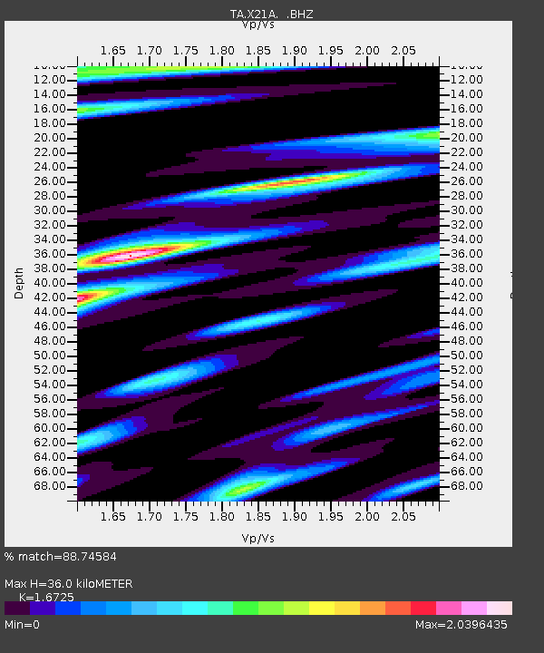
| Estimated Moho Depth: |
36.0 km |
| Estimated Crust Vp/Vs: |
1.67 |
| Assumed Crust Vp: |
6.502 km/s |
| Estimated Crust Vs: |
3.887 km/s |
| Estimated Crust Poisson's Ratio: |
0.22 |
|
| Radial Match: |
88.74584 % |
| Radial Bump: |
395 |
| Transverse Match: |
79.9336 % |
| Transverse Bump: |
388 |
| SOD ConfigId: |
2504 |
| Insert Time: |
2010-03-06 17:16:46.090 +0000 |
| GWidth: |
2.5 |
| Max Bumps: |
400 |
| Tol: |
0.001 |
|

Signal To Noise
| Channel | StoN | STA | LTA |
| TA:X21A: :BHZ:20080706T09:19:20.949011Z | 5.7322397 | 2.1832952E-7 | 3.8087993E-8 |
| TA:X21A: :BHN:20080706T09:19:20.949011Z | 1.5804644 | 7.778581E-8 | 4.921706E-8 |
| TA:X21A: :BHE:20080706T09:19:20.949011Z | 1.4014566 | 1.116059E-7 | 7.963565E-8 |
| Arrivals |
| Ps | 3.9 SECOND |
| PpPs | 14 SECOND |
| PsPs/PpSs | 18 SECOND |


