You are here: Home > Network List > UU - University of Utah Regional Network Stations List
> Station MPU Maple Canyon, UT, USA > Earthquake Result Viewer
MPU Maple Canyon, UT, USA - Earthquake Result Viewer
| Earthquake location: |
Southeast Of Loyalty Islands |
| Earthquake latitude/longitude: |
-22.5/173.1 |
| Earthquake time(UTC): |
2016/08/12 (225) 01:26:35 GMT |
| Earthquake Depth: |
10 km |
| Earthquake Magnitude: |
7.2 MWW, 7.6 MI |
| Earthquake Catalog/Contributor: |
NEIC PDE/NEIC COMCAT |
|
| Network: |
UU University of Utah Regional Network |
| Station: |
MPU Maple Canyon, UT, USA |
| Lat/Lon: |
40.02 N/111.63 W |
| Elevation: |
1909 m |
|
| Distance: |
93.6 deg |
| Az: |
48.088 deg |
| Baz: |
243.654 deg |
| Ray Param: |
0.041227736 |
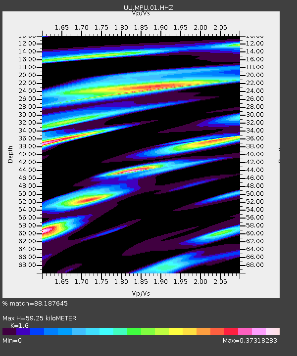
| Estimated Moho Depth: |
59.25 km |
| Estimated Crust Vp/Vs: |
1.60 |
| Assumed Crust Vp: |
6.155 km/s |
| Estimated Crust Vs: |
3.847 km/s |
| Estimated Crust Poisson's Ratio: |
0.18 |
|
| Radial Match: |
88.187645 % |
| Radial Bump: |
323 |
| Transverse Match: |
78.11669 % |
| Transverse Bump: |
400 |
| SOD ConfigId: |
1634031 |
| Insert Time: |
2016-08-26 01:30:31.223 +0000 |
| GWidth: |
2.5 |
| Max Bumps: |
400 |
| Tol: |
0.001 |
|

Signal To Noise
| Channel | StoN | STA | LTA |
| UU:MPU:01:HHZ:20160812T01:39:19.765Z | 2.7409759 | 4.248931E-9 | 1.5501527E-9 |
| UU:MPU:01:HHN:20160812T01:39:19.765Z | 0.62620866 | 1.3540871E-9 | 2.1623576E-9 |
| UU:MPU:01:HHE:20160812T01:39:19.765Z | 1.4530973 | 2.6516467E-9 | 1.8248238E-9 |
| Arrivals |
| Ps | 5.9 SECOND |
| PpPs | 25 SECOND |
| PsPs/PpSs | 30 SECOND |


