You are here: Home > Network List > UW - Pacific Northwest Regional Seismic Network Stations List
> Station UMAT Pilot Rock, OR, USA > Earthquake Result Viewer
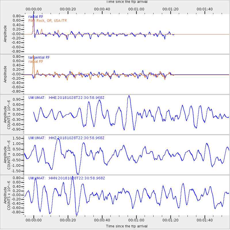
UMAT Pilot Rock, OR, USA - Earthquake Result Viewer
*The percent match for this event was below the threshold and hence no stack was calculated.
| Earthquake location: |
Off Coast Of Central America |
| Earthquake latitude/longitude: |
12.9/-90.4 |
| Earthquake time(UTC): |
2018/10/28 (301) 22:23:54 GMT |
| Earthquake Depth: |
25 km |
| Earthquake Magnitude: |
6.1 Mww |
| Earthquake Catalog/Contributor: |
NEIC PDE/us |
|
| Network: |
UW Pacific Northwest Regional Seismic Network |
| Station: |
UMAT Pilot Rock, OR, USA |
| Lat/Lon: |
45.29 N/118.96 W |
| Elevation: |
1318 m |
|
| Distance: |
40.4 deg |
| Az: |
328.571 deg |
| Baz: |
133.933 deg |
| Ray Param: |
$rayparam |
*The percent match for this event was below the threshold and hence was not used in the summary stack. |
|
| Radial Match: |
65.64542 % |
| Radial Bump: |
322 |
| Transverse Match: |
75.27739 % |
| Transverse Bump: |
390 |
| SOD ConfigId: |
13570011 |
| Insert Time: |
2019-05-01 15:59:27.313 +0000 |
| GWidth: |
2.5 |
| Max Bumps: |
400 |
| Tol: |
0.001 |
|
Signal To Noise
| Channel | StoN | STA | LTA |
| UW:UMAT: :HHZ:20181028T22:30:58.968Z | 2.1425273 | 5.156191E-7 | 2.406593E-7 |
| UW:UMAT: :HHN:20181028T22:30:58.968Z | 2.3904014 | 5.1634487E-7 | 2.160076E-7 |
| UW:UMAT: :HHE:20181028T22:30:58.968Z | 2.9498198 | 5.3671556E-7 | 1.819486E-7 |
| Arrivals |
| Ps | |
| PpPs | |
| PsPs/PpSs | |


