You are here: Home > Network List > TA - USArray Transportable Network (new EarthScope stations) Stations List
> Station X21A Alamocita Creek, Datil, NM, USA > Earthquake Result Viewer
X21A Alamocita Creek, Datil, NM, USA - Earthquake Result Viewer
| Earthquake location: |
Andreanof Islands, Aleutian Is. |
| Earthquake latitude/longitude: |
51.9/-177.5 |
| Earthquake time(UTC): |
2008/05/02 (123) 01:33:37 GMT |
| Earthquake Depth: |
14 km |
| Earthquake Magnitude: |
6.3 MB, 6.8 MS, 6.6 MW, 6.6 MW |
| Earthquake Catalog/Contributor: |
WHDF/NEIC |
|
| Network: |
TA USArray Transportable Network (new EarthScope stations) |
| Station: |
X21A Alamocita Creek, Datil, NM, USA |
| Lat/Lon: |
34.45 N/107.79 W |
| Elevation: |
2141 m |
|
| Distance: |
51.7 deg |
| Az: |
80.866 deg |
| Baz: |
312.199 deg |
| Ray Param: |
0.0672021 |
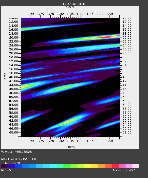
| Estimated Moho Depth: |
19.0 km |
| Estimated Crust Vp/Vs: |
2.10 |
| Assumed Crust Vp: |
6.502 km/s |
| Estimated Crust Vs: |
3.1 km/s |
| Estimated Crust Poisson's Ratio: |
0.35 |
|
| Radial Match: |
98.15525 % |
| Radial Bump: |
281 |
| Transverse Match: |
93.19822 % |
| Transverse Bump: |
400 |
| SOD ConfigId: |
2504 |
| Insert Time: |
2010-03-06 17:16:57.339 +0000 |
| GWidth: |
2.5 |
| Max Bumps: |
400 |
| Tol: |
0.001 |
|

Signal To Noise
| Channel | StoN | STA | LTA |
| TA:X21A: :BHN:20080502T01:42:13.099009Z | 18.618284 | 1.7813968E-6 | 9.5679965E-8 |
| TA:X21A: :BHE:20080502T01:42:13.099009Z | 6.196931 | 8.2018175E-7 | 1.3235291E-7 |
| TA:X21A: :BHZ:20080502T01:42:13.099009Z | 5.8970494 | 7.192845E-7 | 1.2197363E-7 |
| Arrivals |
| Ps | 3.4 SECOND |
| PpPs | 8.6 SECOND |
| PsPs/PpSs | 12 SECOND |


