You are here: Home > Network List > TA - USArray Transportable Network (new EarthScope stations) Stations List
> Station X21A Alamocita Creek, Datil, NM, USA > Earthquake Result Viewer
X21A Alamocita Creek, Datil, NM, USA - Earthquake Result Viewer
| Earthquake location: |
Trinidad |
| Earthquake latitude/longitude: |
10.3/-60.4 |
| Earthquake time(UTC): |
2008/07/03 (185) 06:34:53 GMT |
| Earthquake Depth: |
34 km |
| Earthquake Magnitude: |
5.7 MB, 5.5 MS, 5.8 MW, 5.7 MW |
| Earthquake Catalog/Contributor: |
WHDF/NEIC |
|
| Network: |
TA USArray Transportable Network (new EarthScope stations) |
| Station: |
X21A Alamocita Creek, Datil, NM, USA |
| Lat/Lon: |
34.45 N/107.79 W |
| Elevation: |
2141 m |
|
| Distance: |
49.4 deg |
| Az: |
306.809 deg |
| Baz: |
107.552 deg |
| Ray Param: |
0.06866806 |
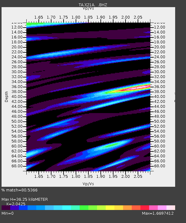
| Estimated Moho Depth: |
36.25 km |
| Estimated Crust Vp/Vs: |
2.04 |
| Assumed Crust Vp: |
6.502 km/s |
| Estimated Crust Vs: |
3.183 km/s |
| Estimated Crust Poisson's Ratio: |
0.34 |
|
| Radial Match: |
80.5366 % |
| Radial Bump: |
363 |
| Transverse Match: |
62.35543 % |
| Transverse Bump: |
370 |
| SOD ConfigId: |
2504 |
| Insert Time: |
2010-03-06 17:17:12.351 +0000 |
| GWidth: |
2.5 |
| Max Bumps: |
400 |
| Tol: |
0.001 |
|

Signal To Noise
| Channel | StoN | STA | LTA |
| TA:X21A: :BHZ:20080703T06:43:09.425006Z | 1.8245205 | 1.8528016E-7 | 1.0155006E-7 |
| TA:X21A: :BHN:20080703T06:43:09.425006Z | 0.93642825 | 9.917813E-8 | 1.0591109E-7 |
| TA:X21A: :BHE:20080703T06:43:09.425006Z | 1.9839523 | 1.4230812E-7 | 7.172961E-8 |
| Arrivals |
| Ps | 6.1 SECOND |
| PpPs | 16 SECOND |
| PsPs/PpSs | 22 SECOND |


