You are here: Home > Network List > TA - USArray Transportable Network (new EarthScope stations) Stations List
> Station X21A Alamocita Creek, Datil, NM, USA > Earthquake Result Viewer
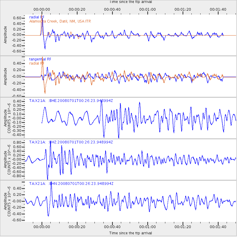
X21A Alamocita Creek, Datil, NM, USA - Earthquake Result Viewer
*The percent match for this event was below the threshold and hence no stack was calculated.
| Earthquake location: |
Central Peru |
| Earthquake latitude/longitude: |
-10.4/-75.5 |
| Earthquake time(UTC): |
2008/07/01 (183) 00:17:33 GMT |
| Earthquake Depth: |
33 km |
| Earthquake Magnitude: |
5.5 MW, 5.0 MS, 5.4 MB, 5.3 ML |
| Earthquake Catalog/Contributor: |
WHDF/NEIC |
|
| Network: |
TA USArray Transportable Network (new EarthScope stations) |
| Station: |
X21A Alamocita Creek, Datil, NM, USA |
| Lat/Lon: |
34.45 N/107.79 W |
| Elevation: |
2141 m |
|
| Distance: |
54.1 deg |
| Az: |
326.977 deg |
| Baz: |
139.548 deg |
| Ray Param: |
$rayparam |
*The percent match for this event was below the threshold and hence was not used in the summary stack. |
|
| Radial Match: |
74.778435 % |
| Radial Bump: |
400 |
| Transverse Match: |
64.17266 % |
| Transverse Bump: |
400 |
| SOD ConfigId: |
2504 |
| Insert Time: |
2010-03-06 17:17:27.751 +0000 |
| GWidth: |
2.5 |
| Max Bumps: |
400 |
| Tol: |
0.001 |
|
Signal To Noise
| Channel | StoN | STA | LTA |
| TA:X21A: :BHZ:20080701T00:26:23.948994Z | 4.3433185 | 3.8171768E-7 | 8.7886185E-8 |
| TA:X21A: :BHN:20080701T00:26:23.948994Z | 2.2591407 | 1.8778924E-7 | 8.3124185E-8 |
| TA:X21A: :BHE:20080701T00:26:23.948994Z | 1.515361 | 1.5916554E-7 | 1.0503474E-7 |
| Arrivals |
| Ps | |
| PpPs | |
| PsPs/PpSs | |


