You are here: Home > Network List > UW - Pacific Northwest Regional Seismic Network Stations List
> Station UMAT Pilot Rock, OR, USA > Earthquake Result Viewer
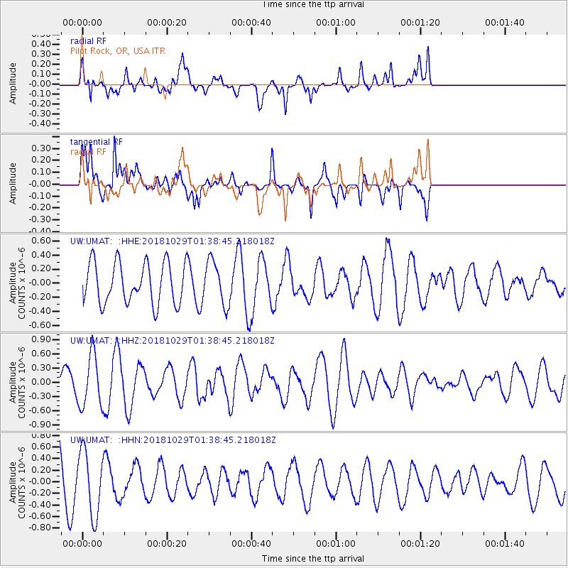
UMAT Pilot Rock, OR, USA - Earthquake Result Viewer
*The percent match for this event was below the threshold and hence no stack was calculated.
| Earthquake location: |
Southeast Of Honshu, Japan |
| Earthquake latitude/longitude: |
31.6/140.2 |
| Earthquake time(UTC): |
2018/10/29 (302) 01:27:44 GMT |
| Earthquake Depth: |
94 km |
| Earthquake Magnitude: |
5.5 Mww |
| Earthquake Catalog/Contributor: |
NEIC PDE/us |
|
| Network: |
UW Pacific Northwest Regional Seismic Network |
| Station: |
UMAT Pilot Rock, OR, USA |
| Lat/Lon: |
45.29 N/118.96 W |
| Elevation: |
1318 m |
|
| Distance: |
75.2 deg |
| Az: |
45.834 deg |
| Baz: |
299.864 deg |
| Ray Param: |
$rayparam |
*The percent match for this event was below the threshold and hence was not used in the summary stack. |
|
| Radial Match: |
65.4303 % |
| Radial Bump: |
400 |
| Transverse Match: |
67.58604 % |
| Transverse Bump: |
400 |
| SOD ConfigId: |
13570011 |
| Insert Time: |
2019-05-01 16:07:27.456 +0000 |
| GWidth: |
2.5 |
| Max Bumps: |
400 |
| Tol: |
0.001 |
|
Signal To Noise
| Channel | StoN | STA | LTA |
| UW:UMAT: :HHZ:20181029T01:38:45.218018Z | 1.8798946 | 5.6331777E-7 | 2.9965392E-7 |
| UW:UMAT: :HHN:20181029T01:38:45.218018Z | 1.2916545 | 5.7067854E-7 | 4.4181982E-7 |
| UW:UMAT: :HHE:20181029T01:38:45.218018Z | 1.095182 | 3.2119922E-7 | 2.9328388E-7 |
| Arrivals |
| Ps | |
| PpPs | |
| PsPs/PpSs | |


