You are here: Home > Network List > WY - Yellowstone Wyoming Seismic Network Stations List
> Station YFT Old Faithful, YNP, WY, USA > Earthquake Result Viewer
YFT Old Faithful, YNP, WY, USA - Earthquake Result Viewer
| Earthquake location: |
Southeast Of Loyalty Islands |
| Earthquake latitude/longitude: |
-22.5/173.1 |
| Earthquake time(UTC): |
2016/08/12 (225) 01:26:35 GMT |
| Earthquake Depth: |
10 km |
| Earthquake Magnitude: |
7.2 MWW, 7.6 MI |
| Earthquake Catalog/Contributor: |
NEIC PDE/NEIC COMCAT |
|
| Network: |
WY Yellowstone Wyoming Seismic Network |
| Station: |
YFT Old Faithful, YNP, WY, USA |
| Lat/Lon: |
44.45 N/110.84 W |
| Elevation: |
2292 m |
|
| Distance: |
96.1 deg |
| Az: |
44.347 deg |
| Baz: |
244.505 deg |
| Ray Param: |
0.040612858 |
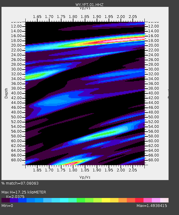
| Estimated Moho Depth: |
17.25 km |
| Estimated Crust Vp/Vs: |
2.04 |
| Assumed Crust Vp: |
6.35 km/s |
| Estimated Crust Vs: |
3.117 km/s |
| Estimated Crust Poisson's Ratio: |
0.34 |
|
| Radial Match: |
87.06063 % |
| Radial Bump: |
400 |
| Transverse Match: |
83.38045 % |
| Transverse Bump: |
400 |
| SOD ConfigId: |
1634031 |
| Insert Time: |
2016-08-26 01:31:17.359 +0000 |
| GWidth: |
2.5 |
| Max Bumps: |
400 |
| Tol: |
0.001 |
|

Signal To Noise
| Channel | StoN | STA | LTA |
| WY:YFT:01:HHZ:20160812T01:39:30.989976Z | 2.4349546 | 4.1622656E-9 | 1.7093811E-9 |
| WY:YFT:01:HHN:20160812T01:39:30.989976Z | 1.4120693 | 2.3623594E-9 | 1.6729769E-9 |
| WY:YFT:01:HHE:20160812T01:39:30.989976Z | 0.9021289 | 1.6457842E-9 | 1.8243338E-9 |
| Arrivals |
| Ps | 2.9 SECOND |
| PpPs | 8.1 SECOND |
| PsPs/PpSs | 11 SECOND |


