You are here: Home > Network List > N4 - Central and EAstern US Network Stations List
> Station Z47B Carrollton, AL, USA > Earthquake Result Viewer
Z47B Carrollton, AL, USA - Earthquake Result Viewer
| Earthquake location: |
Drake Passage |
| Earthquake latitude/longitude: |
-57.4/-66.4 |
| Earthquake time(UTC): |
2018/10/29 (302) 06:54:21 GMT |
| Earthquake Depth: |
10 km |
| Earthquake Magnitude: |
6.3 Mww |
| Earthquake Catalog/Contributor: |
NEIC PDE/us |
|
| Network: |
N4 Central and EAstern US Network |
| Station: |
Z47B Carrollton, AL, USA |
| Lat/Lon: |
33.20 N/88.07 W |
| Elevation: |
64 m |
|
| Distance: |
92.1 deg |
| Az: |
341.959 deg |
| Baz: |
168.467 deg |
| Ray Param: |
0.04151106 |
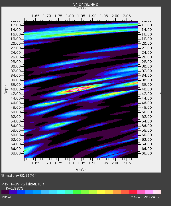
| Estimated Moho Depth: |
39.75 km |
| Estimated Crust Vp/Vs: |
1.84 |
| Assumed Crust Vp: |
6.201 km/s |
| Estimated Crust Vs: |
3.375 km/s |
| Estimated Crust Poisson's Ratio: |
0.29 |
|
| Radial Match: |
80.11764 % |
| Radial Bump: |
400 |
| Transverse Match: |
71.65879 % |
| Transverse Bump: |
386 |
| SOD ConfigId: |
13570011 |
| Insert Time: |
2019-05-01 16:11:11.246 +0000 |
| GWidth: |
2.5 |
| Max Bumps: |
400 |
| Tol: |
0.001 |
|

Signal To Noise
| Channel | StoN | STA | LTA |
| N4:Z47B: :HHZ:20181029T07:06:59.109983Z | 10.902395 | 2.301698E-6 | 2.1111856E-7 |
| N4:Z47B: :HHN:20181029T07:06:59.109983Z | 5.267965 | 1.1528425E-6 | 2.1884021E-7 |
| N4:Z47B: :HHE:20181029T07:06:59.109983Z | 1.2653179 | 4.7219254E-7 | 3.7318094E-7 |
| Arrivals |
| Ps | 5.5 SECOND |
| PpPs | 18 SECOND |
| PsPs/PpSs | 23 SECOND |


