You are here: Home > Network List > TA - USArray Transportable Network (new EarthScope stations) Stations List
> Station X21A Alamocita Creek, Datil, NM, USA > Earthquake Result Viewer
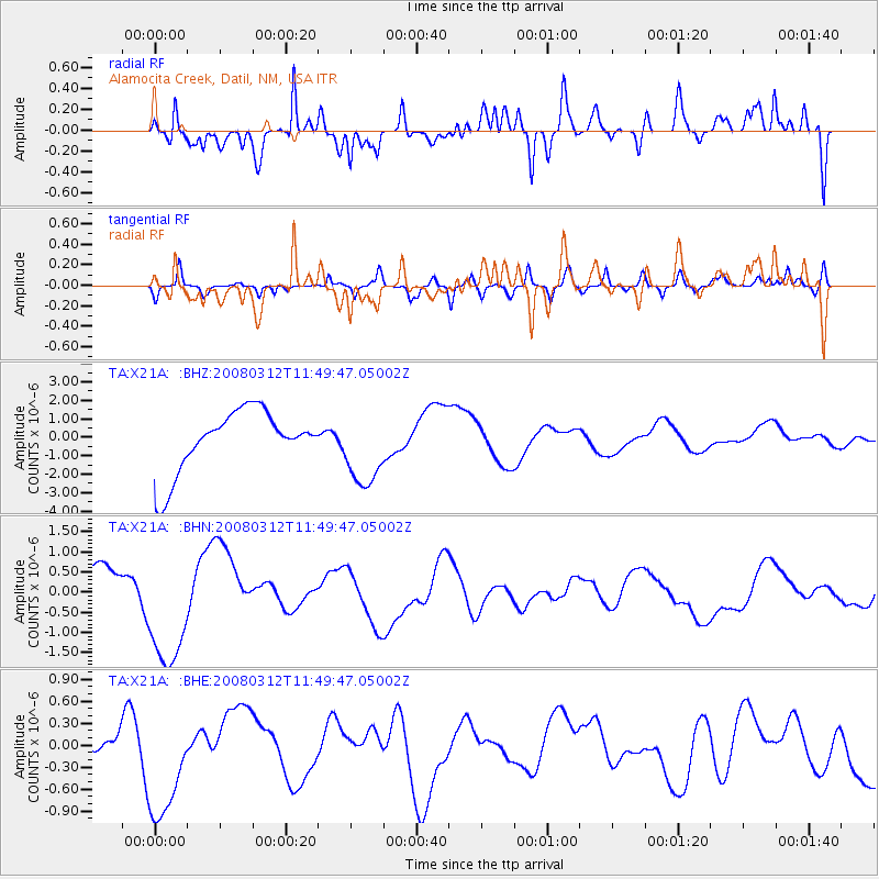
X21A Alamocita Creek, Datil, NM, USA - Earthquake Result Viewer
*The percent match for this event was below the threshold and hence no stack was calculated.
| Earthquake location: |
Vanuatu Islands |
| Earthquake latitude/longitude: |
-16.5/167.2 |
| Earthquake time(UTC): |
2008/03/12 (072) 11:36:55 GMT |
| Earthquake Depth: |
10 km |
| Earthquake Magnitude: |
5.6 MB, 6.3 MW |
| Earthquake Catalog/Contributor: |
WHDF/NEIC |
|
| Network: |
TA USArray Transportable Network (new EarthScope stations) |
| Station: |
X21A Alamocita Creek, Datil, NM, USA |
| Lat/Lon: |
34.45 N/107.79 W |
| Elevation: |
2141 m |
|
| Distance: |
95.2 deg |
| Az: |
55.76 deg |
| Baz: |
253.677 deg |
| Ray Param: |
$rayparam |
*The percent match for this event was below the threshold and hence was not used in the summary stack. |
|
| Radial Match: |
48.094574 % |
| Radial Bump: |
386 |
| Transverse Match: |
64.82622 % |
| Transverse Bump: |
400 |
| SOD ConfigId: |
2504 |
| Insert Time: |
2010-03-06 17:18:22.582 +0000 |
| GWidth: |
2.5 |
| Max Bumps: |
400 |
| Tol: |
0.001 |
|
Signal To Noise
| Channel | StoN | STA | LTA |
| TA:X21A: :BHN:20080312T11:49:47.05002Z | 3.0777545 | 1.5883513E-6 | 5.1607475E-7 |
| TA:X21A: :BHE:20080312T11:49:47.05002Z | 2.3840668 | 7.704525E-7 | 3.2316734E-7 |
| TA:X21A: :BHZ:20080312T11:49:47.05002Z | 1.2542096 | 2.07214E-6 | 1.652148E-6 |
| Arrivals |
| Ps | |
| PpPs | |
| PsPs/PpSs | |


