You are here: Home > Network List > IU - Global Seismograph Network (GSN - IRIS/USGS) Stations List
> Station CTAO Charters Towers, Australia > Earthquake Result Viewer
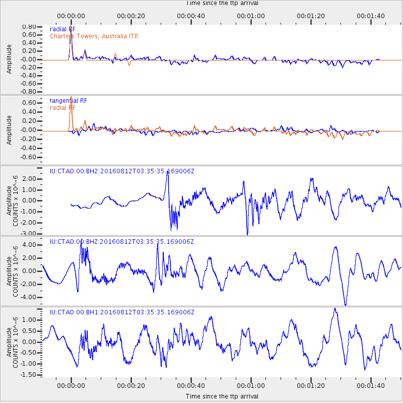
CTAO Charters Towers, Australia - Earthquake Result Viewer
*The percent match for this event was below the threshold and hence no stack was calculated.
| Earthquake location: |
South Of Fiji Islands |
| Earthquake latitude/longitude: |
-25.2/-177.0 |
| Earthquake time(UTC): |
2016/08/12 (225) 03:29:27 GMT |
| Earthquake Depth: |
75 km |
| Earthquake Magnitude: |
6.1 MO |
| Earthquake Catalog/Contributor: |
NEIC PDE/NEIC ALERT |
|
| Network: |
IU Global Seismograph Network (GSN - IRIS/USGS) |
| Station: |
CTAO Charters Towers, Australia |
| Lat/Lon: |
20.09 S/146.25 E |
| Elevation: |
357 m |
|
| Distance: |
34.2 deg |
| Az: |
270.972 deg |
| Baz: |
105.473 deg |
| Ray Param: |
$rayparam |
*The percent match for this event was below the threshold and hence was not used in the summary stack. |
|
| Radial Match: |
79.179245 % |
| Radial Bump: |
400 |
| Transverse Match: |
54.998653 % |
| Transverse Bump: |
400 |
| SOD ConfigId: |
1634031 |
| Insert Time: |
2016-08-26 03:31:51.475 +0000 |
| GWidth: |
2.5 |
| Max Bumps: |
400 |
| Tol: |
0.001 |
|
Signal To Noise
| Channel | StoN | STA | LTA |
| IU:CTAO:00:BHZ:20160812T03:35:35.169006Z | 2.3398836 | 2.0585856E-6 | 8.797812E-7 |
| IU:CTAO:00:BH1:20160812T03:35:35.169006Z | 1.9203272 | 7.3264886E-7 | 3.8152294E-7 |
| IU:CTAO:00:BH2:20160812T03:35:35.169006Z | 4.2529874 | 1.3811521E-6 | 3.2474867E-7 |
| Arrivals |
| Ps | |
| PpPs | |
| PsPs/PpSs | |


