You are here: Home > Network List > TA - USArray Transportable Network (new EarthScope stations) Stations List
> Station D23K Nanushuk River, AK USA > Earthquake Result Viewer
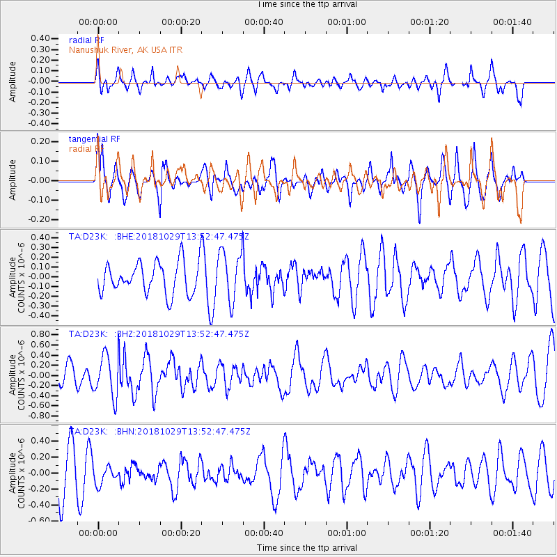
D23K Nanushuk River, AK USA - Earthquake Result Viewer
*The percent match for this event was below the threshold and hence no stack was calculated.
| Earthquake location: |
Mindanao, Philippines |
| Earthquake latitude/longitude: |
8.7/126.8 |
| Earthquake time(UTC): |
2018/10/29 (302) 13:41:13 GMT |
| Earthquake Depth: |
10 km |
| Earthquake Magnitude: |
5.2 Mww |
| Earthquake Catalog/Contributor: |
NEIC PDE/us |
|
| Network: |
TA USArray Transportable Network (new EarthScope stations) |
| Station: |
D23K Nanushuk River, AK USA |
| Lat/Lon: |
68.97 N/150.68 W |
| Elevation: |
406 m |
|
| Distance: |
79.3 deg |
| Az: |
21.365 deg |
| Baz: |
266.142 deg |
| Ray Param: |
$rayparam |
*The percent match for this event was below the threshold and hence was not used in the summary stack. |
|
| Radial Match: |
69.47141 % |
| Radial Bump: |
400 |
| Transverse Match: |
53.86863 % |
| Transverse Bump: |
400 |
| SOD ConfigId: |
13570011 |
| Insert Time: |
2019-05-01 16:16:36.576 +0000 |
| GWidth: |
2.5 |
| Max Bumps: |
400 |
| Tol: |
0.001 |
|
Signal To Noise
| Channel | StoN | STA | LTA |
| TA:D23K: :BHZ:20181029T13:52:47.475Z | 2.773649 | 4.2163077E-7 | 1.5201303E-7 |
| TA:D23K: :BHN:20181029T13:52:47.475Z | 0.5023688 | 1.17407346E-7 | 2.3370748E-7 |
| TA:D23K: :BHE:20181029T13:52:47.475Z | 1.6367403 | 2.626614E-7 | 1.6047835E-7 |
| Arrivals |
| Ps | |
| PpPs | |
| PsPs/PpSs | |


