You are here: Home > Network List > TA - USArray Transportable Network (new EarthScope stations) Stations List
> Station E20K Nigu River, AK, USA > Earthquake Result Viewer
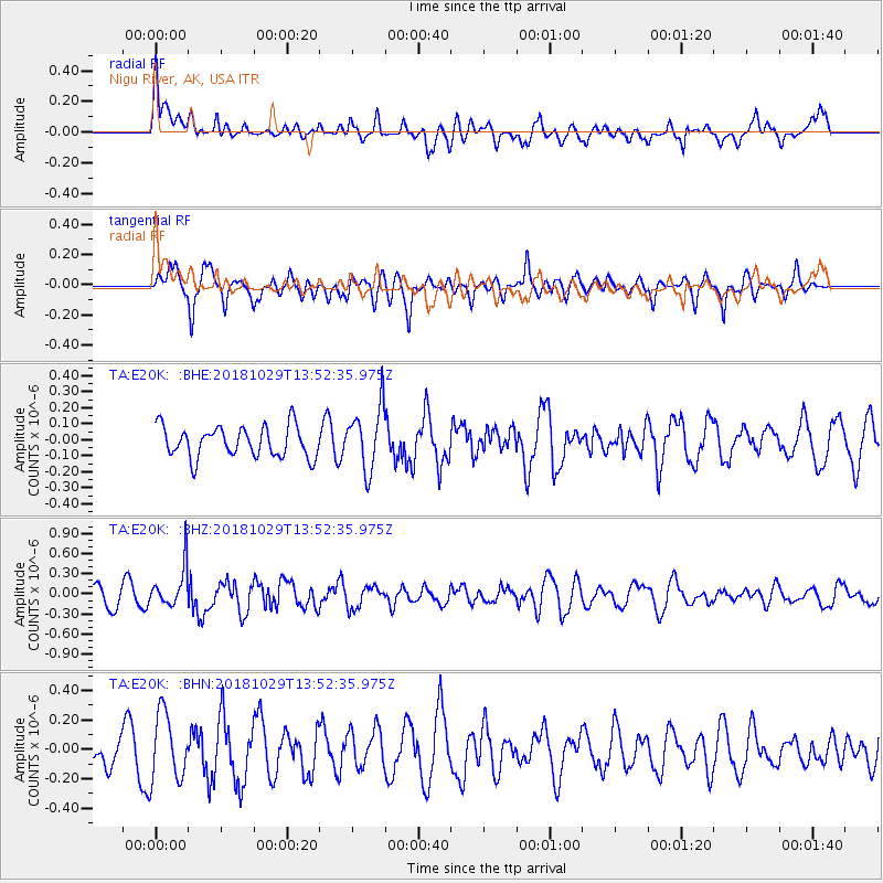
E20K Nigu River, AK, USA - Earthquake Result Viewer
*The percent match for this event was below the threshold and hence no stack was calculated.
| Earthquake location: |
Mindanao, Philippines |
| Earthquake latitude/longitude: |
8.7/126.8 |
| Earthquake time(UTC): |
2018/10/29 (302) 13:41:13 GMT |
| Earthquake Depth: |
10 km |
| Earthquake Magnitude: |
5.2 Mww |
| Earthquake Catalog/Contributor: |
NEIC PDE/us |
|
| Network: |
TA USArray Transportable Network (new EarthScope stations) |
| Station: |
E20K Nigu River, AK, USA |
| Lat/Lon: |
68.26 N/156.19 W |
| Elevation: |
866 m |
|
| Distance: |
77.2 deg |
| Az: |
21.858 deg |
| Baz: |
261.118 deg |
| Ray Param: |
$rayparam |
*The percent match for this event was below the threshold and hence was not used in the summary stack. |
|
| Radial Match: |
60.21567 % |
| Radial Bump: |
400 |
| Transverse Match: |
70.45786 % |
| Transverse Bump: |
400 |
| SOD ConfigId: |
13570011 |
| Insert Time: |
2019-05-01 16:16:39.806 +0000 |
| GWidth: |
2.5 |
| Max Bumps: |
400 |
| Tol: |
0.001 |
|
Signal To Noise
| Channel | StoN | STA | LTA |
| TA:E20K: :BHZ:20181029T13:52:35.975Z | 2.703606 | 2.998608E-7 | 1.1091144E-7 |
| TA:E20K: :BHN:20181029T13:52:35.975Z | 2.523873 | 2.2735239E-7 | 9.008075E-8 |
| TA:E20K: :BHE:20181029T13:52:35.975Z | 2.0590324 | 1.9784729E-7 | 9.6087504E-8 |
| Arrivals |
| Ps | |
| PpPs | |
| PsPs/PpSs | |


