You are here: Home > Network List > TS - TERRAscope (Southern California Seismic Network) Stations List
> Station BAR Barrett Dam, California, USA > Earthquake Result Viewer
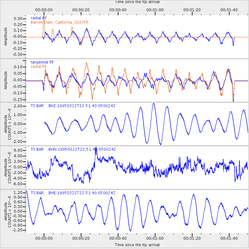
BAR Barrett Dam, California, USA - Earthquake Result Viewer
*The percent match for this event was below the threshold and hence no stack was calculated.
| Earthquake location: |
Southeast Of Loyalty Islands |
| Earthquake latitude/longitude: |
-21.3/169.1 |
| Earthquake time(UTC): |
1995/03/22 (081) 22:39:20 GMT |
| Earthquake Depth: |
33 km |
| Earthquake Magnitude: |
5.6 MS, 5.2 MB, 5.8 UNKNOWN |
| Earthquake Catalog/Contributor: |
WHDF/NEIC |
|
| Network: |
TS TERRAscope (Southern California Seismic Network) |
| Station: |
BAR Barrett Dam, California, USA |
| Lat/Lon: |
32.68 N/116.67 W |
| Elevation: |
548 m |
|
| Distance: |
88.9 deg |
| Az: |
54.258 deg |
| Baz: |
243.8 deg |
| Ray Param: |
$rayparam |
*The percent match for this event was below the threshold and hence was not used in the summary stack. |
|
| Radial Match: |
76.23966 % |
| Radial Bump: |
373 |
| Transverse Match: |
50.219444 % |
| Transverse Bump: |
380 |
| SOD ConfigId: |
4480 |
| Insert Time: |
2010-02-26 13:59:43.659 +0000 |
| GWidth: |
2.5 |
| Max Bumps: |
400 |
| Tol: |
0.001 |
|
Signal To Noise
| Channel | StoN | STA | LTA |
| TS:BAR: :BHN:19950322T22:51:40.050024Z | 1.82294 | 2.5235126E-6 | 1.3843093E-6 |
| TS:BAR: :BHE:19950322T22:51:40.050024Z | 0.3335968 | 2.1256125E-7 | 6.371801E-7 |
| TS:BAR: :BHZ:19950322T22:51:40.050024Z | 1.4248998 | 7.308136E-7 | 5.128877E-7 |
| Arrivals |
| Ps | |
| PpPs | |
| PsPs/PpSs | |


