You are here: Home > Network List > US - United States National Seismic Network Stations List
> Station LAO LASA Array, Montana, USA > Earthquake Result Viewer
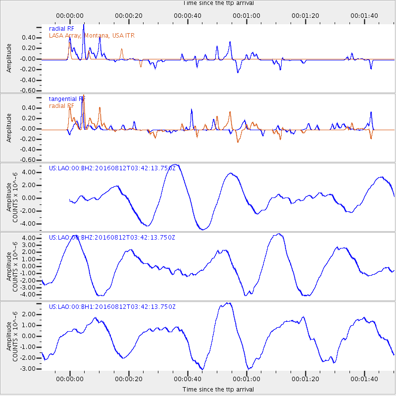
LAO LASA Array, Montana, USA - Earthquake Result Viewer
*The percent match for this event was below the threshold and hence no stack was calculated.
| Earthquake location: |
South Of Fiji Islands |
| Earthquake latitude/longitude: |
-25.2/-177.0 |
| Earthquake time(UTC): |
2016/08/12 (225) 03:29:27 GMT |
| Earthquake Depth: |
75 km |
| Earthquake Magnitude: |
6.1 MO |
| Earthquake Catalog/Contributor: |
NEIC PDE/NEIC ALERT |
|
| Network: |
US United States National Seismic Network |
| Station: |
LAO LASA Array, Montana, USA |
| Lat/Lon: |
46.69 N/106.22 W |
| Elevation: |
902 m |
|
| Distance: |
95.8 deg |
| Az: |
40.801 deg |
| Baz: |
239.311 deg |
| Ray Param: |
$rayparam |
*The percent match for this event was below the threshold and hence was not used in the summary stack. |
|
| Radial Match: |
92.974434 % |
| Radial Bump: |
363 |
| Transverse Match: |
74.21736 % |
| Transverse Bump: |
400 |
| SOD ConfigId: |
1634031 |
| Insert Time: |
2016-08-26 03:33:21.096 +0000 |
| GWidth: |
2.5 |
| Max Bumps: |
400 |
| Tol: |
0.001 |
|
Signal To Noise
| Channel | StoN | STA | LTA |
| US:LAO:00:BHZ:20160812T03:42:13.750Z | 3.9958136 | 4.063449E-6 | 1.0169266E-6 |
| US:LAO:00:BH1:20160812T03:42:13.750Z | 0.631286 | 8.4330867E-7 | 1.3358583E-6 |
| US:LAO:00:BH2:20160812T03:42:13.750Z | 2.316064 | 3.138414E-6 | 1.3550638E-6 |
| Arrivals |
| Ps | |
| PpPs | |
| PsPs/PpSs | |


