You are here: Home > Network List > TA - USArray Transportable Network (new EarthScope stations) Stations List
> Station Y20A Horse Springs, Datil, NM, USA > Earthquake Result Viewer
Y20A Horse Springs, Datil, NM, USA - Earthquake Result Viewer

| Earthquake location: |
Fiji Islands Region |
| Earthquake latitude/longitude: |
-17.3/-177.3 |
| Earthquake time(UTC): |
2008/07/19 (201) 22:39:52 GMT |
| Earthquake Depth: |
391 km |
| Earthquake Magnitude: |
5.9 MB, 6.4 MW, 6.4 MW |
| Earthquake Catalog/Contributor: |
WHDF/NEIC |
|
| Network: |
TA USArray Transportable Network (new EarthScope stations) |
| Station: |
Y20A Horse Springs, Datil, NM, USA |
| Lat/Lon: |
33.91 N/108.38 W |
| Elevation: |
2177 m |
|
| Distance: |
83.0 deg |
| Az: |
51.428 deg |
| Baz: |
243.885 deg |
| Ray Param: |
0.045412295 |
| Estimated Moho Depth: |
38.75 km |
| Estimated Crust Vp/Vs: |
1.78 |
| Assumed Crust Vp: |
6.276 km/s |
| Estimated Crust Vs: |
3.526 km/s |
| Estimated Crust Poisson's Ratio: |
0.27 |
|
| Radial Match: |
91.32674 % |
| Radial Bump: |
400 |
| Transverse Match: |
80.898506 % |
| Transverse Bump: |
375 |
| SOD ConfigId: |
2504 |
| Insert Time: |
2010-03-06 17:19:09.377 +0000 |
| GWidth: |
2.5 |
| Max Bumps: |
400 |
| Tol: |
0.001 |
|
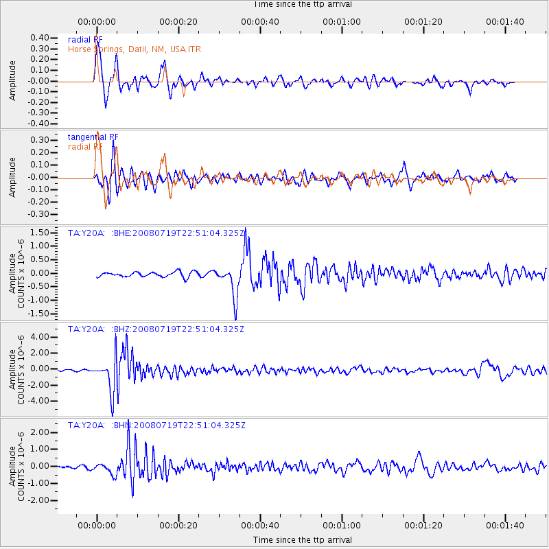
Signal To Noise
| Channel | StoN | STA | LTA |
| TA:Y20A: :BHZ:20080719T22:51:04.325Z | 30.29651 | 2.1892297E-6 | 7.226013E-8 |
| TA:Y20A: :BHN:20080719T22:51:04.325Z | 4.266456 | 3.285363E-7 | 7.700449E-8 |
| TA:Y20A: :BHE:20080719T22:51:04.325Z | 6.4817567 | 5.947895E-7 | 9.176363E-8 |
| Arrivals |
| Ps | 4.9 SECOND |
| PpPs | 17 SECOND |
| PsPs/PpSs | 22 SECOND |


