You are here: Home > Network List > TA - USArray Transportable Network (new EarthScope stations) Stations List
> Station Y20A Horse Springs, Datil, NM, USA > Earthquake Result Viewer
Y20A Horse Springs, Datil, NM, USA - Earthquake Result Viewer

| Earthquake location: |
Easter Island Region |
| Earthquake latitude/longitude: |
-28.5/-112.8 |
| Earthquake time(UTC): |
2008/08/19 (232) 10:58:00 GMT |
| Earthquake Depth: |
9.0 km |
| Earthquake Magnitude: |
5.5 MB, 5.3 MS, 5.7 MW, 5.7 MW |
| Earthquake Catalog/Contributor: |
WHDF/NEIC |
|
| Network: |
TA USArray Transportable Network (new EarthScope stations) |
| Station: |
Y20A Horse Springs, Datil, NM, USA |
| Lat/Lon: |
33.91 N/108.38 W |
| Elevation: |
2177 m |
|
| Distance: |
62.3 deg |
| Az: |
4.195 deg |
| Baz: |
184.438 deg |
| Ray Param: |
0.060347535 |
| Estimated Moho Depth: |
37.75 km |
| Estimated Crust Vp/Vs: |
1.74 |
| Assumed Crust Vp: |
6.276 km/s |
| Estimated Crust Vs: |
3.602 km/s |
| Estimated Crust Poisson's Ratio: |
0.25 |
|
| Radial Match: |
84.33082 % |
| Radial Bump: |
287 |
| Transverse Match: |
72.92817 % |
| Transverse Bump: |
389 |
| SOD ConfigId: |
2504 |
| Insert Time: |
2010-03-06 17:19:17.738 +0000 |
| GWidth: |
2.5 |
| Max Bumps: |
400 |
| Tol: |
0.001 |
|
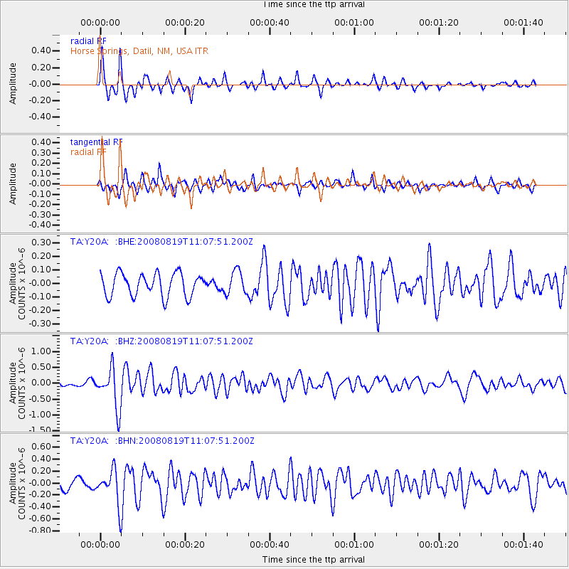
Signal To Noise
| Channel | StoN | STA | LTA |
| TA:Y20A: :BHZ:20080819T11:07:51.200Z | 7.9758854 | 6.4813395E-7 | 8.1261696E-8 |
| TA:Y20A: :BHN:20080819T11:07:51.200Z | 3.6076481 | 2.8942185E-7 | 8.0224524E-8 |
| TA:Y20A: :BHE:20080819T11:07:51.200Z | 1.0298063 | 8.645961E-8 | 8.395716E-8 |
| Arrivals |
| Ps | 4.7 SECOND |
| PpPs | 16 SECOND |
| PsPs/PpSs | 20 SECOND |


