You are here: Home > Network List > TA - USArray Transportable Network (new EarthScope stations) Stations List
> Station Y20A Horse Springs, Datil, NM, USA > Earthquake Result Viewer
Y20A Horse Springs, Datil, NM, USA - Earthquake Result Viewer
| Earthquake location: |
Lake Baykal Region, Russia |
| Earthquake latitude/longitude: |
51.6/104.2 |
| Earthquake time(UTC): |
2008/08/27 (240) 01:35:32 GMT |
| Earthquake Depth: |
16 km |
| Earthquake Magnitude: |
5.8 MB, 6.2 MS, 6.2 MW, 6.2 MW |
| Earthquake Catalog/Contributor: |
WHDF/NEIC |
|
| Network: |
TA USArray Transportable Network (new EarthScope stations) |
| Station: |
Y20A Horse Springs, Datil, NM, USA |
| Lat/Lon: |
33.91 N/108.38 W |
| Elevation: |
2177 m |
|
| Distance: |
90.2 deg |
| Az: |
26.569 deg |
| Baz: |
340.404 deg |
| Ray Param: |
0.041690763 |
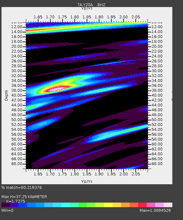
| Estimated Moho Depth: |
37.25 km |
| Estimated Crust Vp/Vs: |
1.73 |
| Assumed Crust Vp: |
6.276 km/s |
| Estimated Crust Vs: |
3.633 km/s |
| Estimated Crust Poisson's Ratio: |
0.25 |
|
| Radial Match: |
80.219376 % |
| Radial Bump: |
326 |
| Transverse Match: |
61.056034 % |
| Transverse Bump: |
319 |
| SOD ConfigId: |
2504 |
| Insert Time: |
2010-03-06 17:19:22.131 +0000 |
| GWidth: |
2.5 |
| Max Bumps: |
400 |
| Tol: |
0.001 |
|

Signal To Noise
| Channel | StoN | STA | LTA |
| TA:Y20A: :BHZ:20080827T01:48:00.025Z | 4.996988 | 2.9999106E-7 | 6.003438E-8 |
| TA:Y20A: :BHN:20080827T01:48:00.025Z | 1.0181566 | 1.2216657E-7 | 1.19988E-7 |
| TA:Y20A: :BHE:20080827T01:48:00.025Z | 0.7573614 | 7.911137E-8 | 1.0445657E-7 |
| Arrivals |
| Ps | 4.4 SECOND |
| PpPs | 16 SECOND |
| PsPs/PpSs | 20 SECOND |


