You are here: Home > Network List > IU - Global Seismograph Network (GSN - IRIS/USGS) Stations List
> Station FURI Mt. Furi, Ethiopia > Earthquake Result Viewer
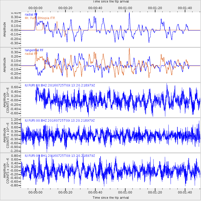
FURI Mt. Furi, Ethiopia - Earthquake Result Viewer
*The percent match for this event was below the threshold and hence no stack was calculated.
| Earthquake location: |
Western Indian-Antarctic Ridge |
| Earthquake latitude/longitude: |
-49.4/126.4 |
| Earthquake time(UTC): |
2016/07/25 (207) 09:00:28 GMT |
| Earthquake Depth: |
10 km |
| Earthquake Magnitude: |
5.5 MB |
| Earthquake Catalog/Contributor: |
NEIC PDE/NEIC COMCAT |
|
| Network: |
IU Global Seismograph Network (GSN - IRIS/USGS) |
| Station: |
FURI Mt. Furi, Ethiopia |
| Lat/Lon: |
8.90 N/38.68 E |
| Elevation: |
2570 m |
|
| Distance: |
95.2 deg |
| Az: |
277.527 deg |
| Baz: |
139.071 deg |
| Ray Param: |
$rayparam |
*The percent match for this event was below the threshold and hence was not used in the summary stack. |
|
| Radial Match: |
56.98813 % |
| Radial Bump: |
400 |
| Transverse Match: |
42.789444 % |
| Transverse Bump: |
400 |
| SOD ConfigId: |
1634031 |
| Insert Time: |
2016-08-26 11:09:40.288 +0000 |
| GWidth: |
2.5 |
| Max Bumps: |
400 |
| Tol: |
0.001 |
|
Signal To Noise
| Channel | StoN | STA | LTA |
| IU:FURI:00:BHZ:20160725T09:13:20.218979Z | 0.88704485 | 2.9899988E-7 | 3.3707414E-7 |
| IU:FURI:00:BH1:20160725T09:13:20.218979Z | 1.405621 | 3.325599E-7 | 2.3659284E-7 |
| IU:FURI:00:BH2:20160725T09:13:20.218979Z | 1.027202 | 2.4537573E-7 | 2.3887776E-7 |
| Arrivals |
| Ps | |
| PpPs | |
| PsPs/PpSs | |


