You are here: Home > Network List > TS - TERRAscope (Southern California Seismic Network) Stations List
> Station BAR Barrett Dam, California, USA > Earthquake Result Viewer
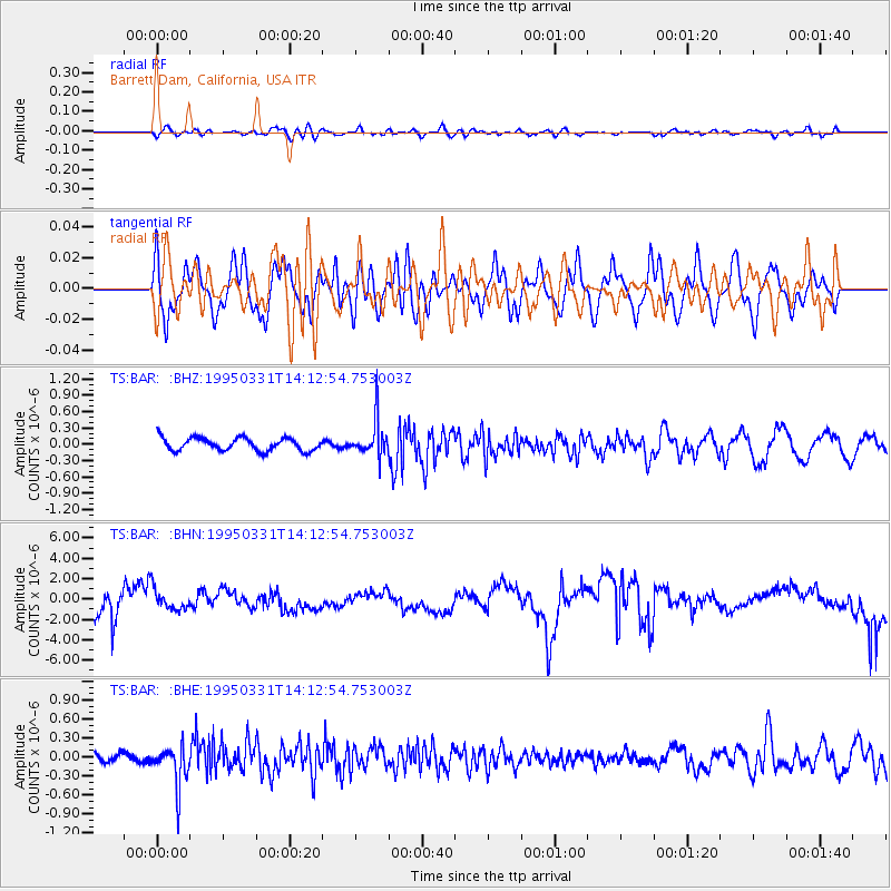
BAR Barrett Dam, California, USA - Earthquake Result Viewer
*The percent match for this event was below the threshold and hence no stack was calculated.
| Earthquake location: |
Sea Of Japan |
| Earthquake latitude/longitude: |
38.2/135.1 |
| Earthquake time(UTC): |
1995/03/31 (090) 14:01:40 GMT |
| Earthquake Depth: |
365 km |
| Earthquake Magnitude: |
6.0 MB, 6.2 UNKNOWN, 6.3 MW |
| Earthquake Catalog/Contributor: |
WHDF/NEIC |
|
| Network: |
TS TERRAscope (Southern California Seismic Network) |
| Station: |
BAR Barrett Dam, California, USA |
| Lat/Lon: |
32.68 N/116.67 W |
| Elevation: |
548 m |
|
| Distance: |
83.0 deg |
| Az: |
53.791 deg |
| Baz: |
311.035 deg |
| Ray Param: |
$rayparam |
*The percent match for this event was below the threshold and hence was not used in the summary stack. |
|
| Radial Match: |
42.01431 % |
| Radial Bump: |
400 |
| Transverse Match: |
56.02988 % |
| Transverse Bump: |
400 |
| SOD ConfigId: |
4480 |
| Insert Time: |
2010-02-26 13:59:44.334 +0000 |
| GWidth: |
2.5 |
| Max Bumps: |
400 |
| Tol: |
0.001 |
|
Signal To Noise
| Channel | StoN | STA | LTA |
| TS:BAR: :BHN:19950331T14:12:54.753003Z | 0.58074737 | 1.0308024E-6 | 1.7749584E-6 |
| TS:BAR: :BHE:19950331T14:12:54.753003Z | 4.769002 | 3.130291E-7 | 6.563828E-8 |
| TS:BAR: :BHZ:19950331T14:12:54.753003Z | 2.7606401 | 3.2803968E-7 | 1.188274E-7 |
| Arrivals |
| Ps | |
| PpPs | |
| PsPs/PpSs | |


