You are here: Home > Network List > CN - Canadian National Seismograph Network Stations List
> Station INK INUVIK, NT > Earthquake Result Viewer
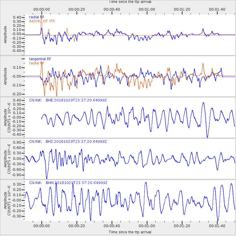
INK INUVIK, NT - Earthquake Result Viewer
*The percent match for this event was below the threshold and hence no stack was calculated.
| Earthquake location: |
Central East Pacific Rise |
| Earthquake latitude/longitude: |
-4.6/-105.9 |
| Earthquake time(UTC): |
2018/10/29 (302) 23:26:09 GMT |
| Earthquake Depth: |
10 km |
| Earthquake Magnitude: |
5.8 Mww |
| Earthquake Catalog/Contributor: |
NEIC PDE/us |
|
| Network: |
CN Canadian National Seismograph Network |
| Station: |
INK INUVIK, NT |
| Lat/Lon: |
68.31 N/133.53 W |
| Elevation: |
44 m |
|
| Distance: |
75.2 deg |
| Az: |
349.734 deg |
| Baz: |
151.454 deg |
| Ray Param: |
$rayparam |
*The percent match for this event was below the threshold and hence was not used in the summary stack. |
|
| Radial Match: |
46.762615 % |
| Radial Bump: |
400 |
| Transverse Match: |
52.925224 % |
| Transverse Bump: |
400 |
| SOD ConfigId: |
13570011 |
| Insert Time: |
2019-05-01 16:29:10.934 +0000 |
| GWidth: |
2.5 |
| Max Bumps: |
400 |
| Tol: |
0.001 |
|
Signal To Noise
| Channel | StoN | STA | LTA |
| CN:INK: :BHZ:20181029T23:37:20.64999Z | 2.731854 | 5.085677E-7 | 1.8616211E-7 |
| CN:INK: :BHN:20181029T23:37:20.64999Z | 1.1643621 | 1.4519725E-7 | 1.2470112E-7 |
| CN:INK: :BHE:20181029T23:37:20.64999Z | 1.3632029 | 1.1820329E-7 | 8.6709974E-8 |
| Arrivals |
| Ps | |
| PpPs | |
| PsPs/PpSs | |


