You are here: Home > Network List > TA - USArray Transportable Network (new EarthScope stations) Stations List
> Station Y20A Horse Springs, Datil, NM, USA > Earthquake Result Viewer
Y20A Horse Springs, Datil, NM, USA - Earthquake Result Viewer
| Earthquake location: |
Samoa Islands Region |
| Earthquake latitude/longitude: |
-15.8/-172.6 |
| Earthquake time(UTC): |
2009/09/29 (272) 23:45:03 GMT |
| Earthquake Depth: |
10 km |
| Earthquake Magnitude: |
6.0 MB, 5.8 MS |
| Earthquake Catalog/Contributor: |
WHDF/NEIC |
|
| Network: |
TA USArray Transportable Network (new EarthScope stations) |
| Station: |
Y20A Horse Springs, Datil, NM, USA |
| Lat/Lon: |
33.91 N/108.38 W |
| Elevation: |
2177 m |
|
| Distance: |
78.6 deg |
| Az: |
49.795 deg |
| Baz: |
242.121 deg |
| Ray Param: |
0.049551923 |
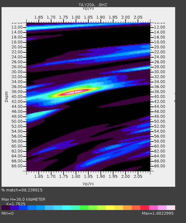
| Estimated Moho Depth: |
38.0 km |
| Estimated Crust Vp/Vs: |
1.79 |
| Assumed Crust Vp: |
6.276 km/s |
| Estimated Crust Vs: |
3.501 km/s |
| Estimated Crust Poisson's Ratio: |
0.27 |
|
| Radial Match: |
86.239815 % |
| Radial Bump: |
328 |
| Transverse Match: |
78.72726 % |
| Transverse Bump: |
372 |
| SOD ConfigId: |
2622 |
| Insert Time: |
2010-03-06 17:19:56.947 +0000 |
| GWidth: |
2.5 |
| Max Bumps: |
400 |
| Tol: |
0.001 |
|
Signal To Noise
| Channel | StoN | STA | LTA |
| TA:Y20A: :BHZ:20090929T23:56:33.699014Z | 1.4769812 | 3.6545302E-7 | 2.474324E-7 |
| TA:Y20A: :BHN:20090929T23:56:33.699014Z | 1.8897837 | 2.693499E-7 | 1.4252949E-7 |
| TA:Y20A: :BHE:20090929T23:56:33.699014Z | 0.510677 | 1.2041973E-7 | 2.3580411E-7 |
| Arrivals |
| Ps | 4.9 SECOND |
| PpPs | 16 SECOND |
| PsPs/PpSs | 21 SECOND |


