You are here: Home > Network List > TA - USArray Transportable Network (new EarthScope stations) Stations List
> Station Y20A Horse Springs, Datil, NM, USA > Earthquake Result Viewer
Y20A Horse Springs, Datil, NM, USA - Earthquake Result Viewer
| Earthquake location: |
Tonga Islands |
| Earthquake latitude/longitude: |
-16.3/-173.5 |
| Earthquake time(UTC): |
2009/10/02 (275) 01:07:39 GMT |
| Earthquake Depth: |
8.0 km |
| Earthquake Magnitude: |
6.1 MB, 6.0 MS, 6.1 MW, 6.1 MW |
| Earthquake Catalog/Contributor: |
WHDF/NEIC |
|
| Network: |
TA USArray Transportable Network (new EarthScope stations) |
| Station: |
Y20A Horse Springs, Datil, NM, USA |
| Lat/Lon: |
33.91 N/108.38 W |
| Elevation: |
2177 m |
|
| Distance: |
79.6 deg |
| Az: |
50.085 deg |
| Baz: |
242.311 deg |
| Ray Param: |
0.04887513 |
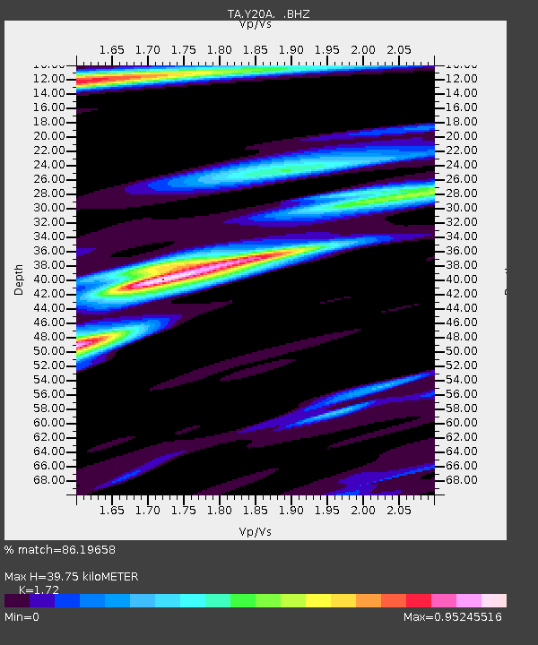
| Estimated Moho Depth: |
39.75 km |
| Estimated Crust Vp/Vs: |
1.72 |
| Assumed Crust Vp: |
6.276 km/s |
| Estimated Crust Vs: |
3.649 km/s |
| Estimated Crust Poisson's Ratio: |
0.24 |
|
| Radial Match: |
86.19658 % |
| Radial Bump: |
313 |
| Transverse Match: |
75.65257 % |
| Transverse Bump: |
393 |
| SOD ConfigId: |
2622 |
| Insert Time: |
2010-03-06 17:19:59.405 +0000 |
| GWidth: |
2.5 |
| Max Bumps: |
400 |
| Tol: |
0.001 |
|
Signal To Noise
| Channel | StoN | STA | LTA |
| TA:Y20A: :BHZ:20091002T01:19:15.275015Z | 3.5860653 | 4.1278432E-7 | 1.15107866E-7 |
| TA:Y20A: :BHN:20091002T01:19:15.275015Z | 1.0383615 | 1.3616079E-7 | 1.3113043E-7 |
| TA:Y20A: :BHE:20091002T01:19:15.275015Z | 0.5227797 | 7.6430936E-8 | 1.4620103E-7 |
| Arrivals |
| Ps | 4.7 SECOND |
| PpPs | 17 SECOND |
| PsPs/PpSs | 21 SECOND |


