You are here: Home > Network List > TA - USArray Transportable Network (new EarthScope stations) Stations List
> Station Y20A Horse Springs, Datil, NM, USA > Earthquake Result Viewer
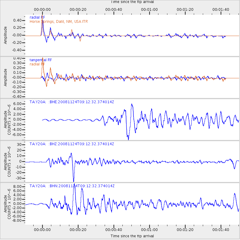
Y20A Horse Springs, Datil, NM, USA - Earthquake Result Viewer
| Earthquake location: |
Sea Of Okhotsk |
| Earthquake latitude/longitude: |
54.2/154.3 |
| Earthquake time(UTC): |
2008/11/24 (329) 09:02:58 GMT |
| Earthquake Depth: |
492 km |
| Earthquake Magnitude: |
6.5 MB, 7.3 MW, 7.3 MW |
| Earthquake Catalog/Contributor: |
WHDF/NEIC |
|
| Network: |
TA USArray Transportable Network (new EarthScope stations) |
| Station: |
Y20A Horse Springs, Datil, NM, USA |
| Lat/Lon: |
33.91 N/108.38 W |
| Elevation: |
2177 m |
|
| Distance: |
67.2 deg |
| Az: |
63.474 deg |
| Baz: |
320.798 deg |
| Ray Param: |
0.055418048 |
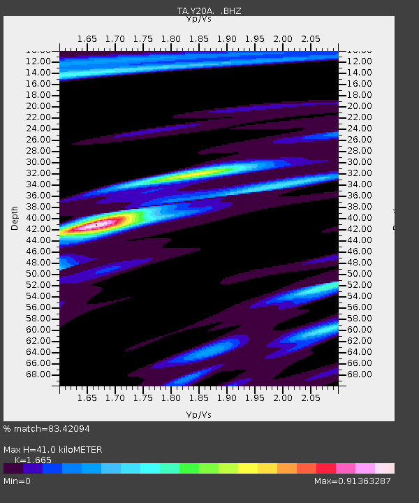
| Estimated Moho Depth: |
41.0 km |
| Estimated Crust Vp/Vs: |
1.66 |
| Assumed Crust Vp: |
6.276 km/s |
| Estimated Crust Vs: |
3.769 km/s |
| Estimated Crust Poisson's Ratio: |
0.22 |
|
| Radial Match: |
83.42094 % |
| Radial Bump: |
289 |
| Transverse Match: |
73.553795 % |
| Transverse Bump: |
290 |
| SOD ConfigId: |
2658 |
| Insert Time: |
2010-03-06 17:20:13.389 +0000 |
| GWidth: |
2.5 |
| Max Bumps: |
400 |
| Tol: |
0.001 |
|
Signal To Noise
| Channel | StoN | STA | LTA |
| TA:Y20A: :BHZ:20081124T09:12:32.374014Z | 20.17712 | 3.5736853E-6 | 1.7711572E-7 |
| TA:Y20A: :BHN:20081124T09:12:32.374014Z | 4.6850204 | 8.386057E-7 | 1.7899723E-7 |
| TA:Y20A: :BHE:20081124T09:12:32.374014Z | 3.1311495 | 6.3263684E-7 | 2.020462E-7 |
| Arrivals |
| Ps | 4.5 SECOND |
| PpPs | 17 SECOND |
| PsPs/PpSs | 21 SECOND |


