You are here: Home > Network List > TA - USArray Transportable Network (new EarthScope stations) Stations List
> Station Y20A Horse Springs, Datil, NM, USA > Earthquake Result Viewer
Y20A Horse Springs, Datil, NM, USA - Earthquake Result Viewer
| Earthquake location: |
Panama |
| Earthquake latitude/longitude: |
9.6/-79.0 |
| Earthquake time(UTC): |
2009/07/04 (185) 06:49:35 GMT |
| Earthquake Depth: |
38 km |
| Earthquake Magnitude: |
6.0 MB, 5.5 MS, 6.0 MW, 6.0 MW |
| Earthquake Catalog/Contributor: |
WHDF/NEIC |
|
| Network: |
TA USArray Transportable Network (new EarthScope stations) |
| Station: |
Y20A Horse Springs, Datil, NM, USA |
| Lat/Lon: |
33.91 N/108.38 W |
| Elevation: |
2177 m |
|
| Distance: |
36.3 deg |
| Az: |
316.324 deg |
| Baz: |
125.023 deg |
| Ray Param: |
0.076701276 |
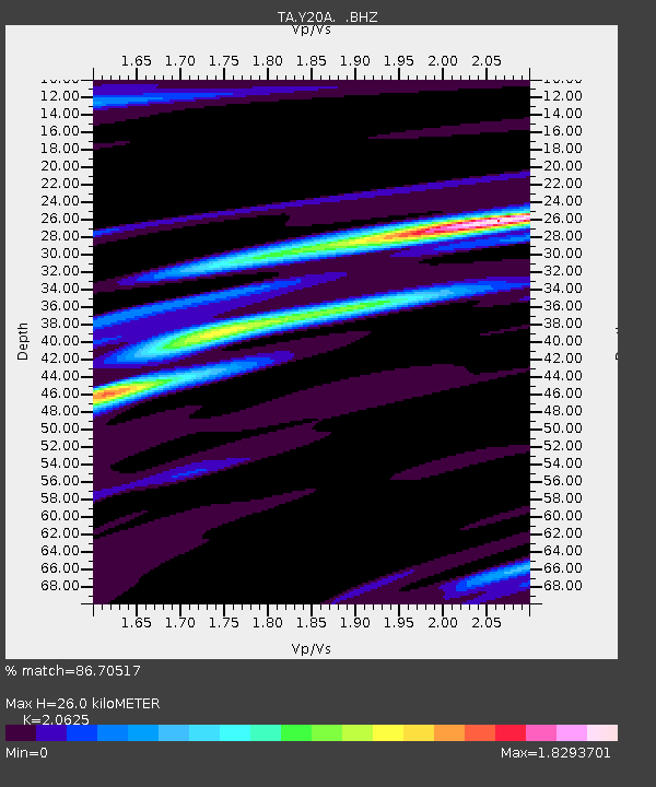
| Estimated Moho Depth: |
26.0 km |
| Estimated Crust Vp/Vs: |
2.06 |
| Assumed Crust Vp: |
6.276 km/s |
| Estimated Crust Vs: |
3.043 km/s |
| Estimated Crust Poisson's Ratio: |
0.35 |
|
| Radial Match: |
86.70517 % |
| Radial Bump: |
347 |
| Transverse Match: |
70.09438 % |
| Transverse Bump: |
400 |
| SOD ConfigId: |
2648 |
| Insert Time: |
2010-03-06 17:20:22.510 +0000 |
| GWidth: |
2.5 |
| Max Bumps: |
400 |
| Tol: |
0.001 |
|
Signal To Noise
| Channel | StoN | STA | LTA |
| TA:Y20A: :BHZ:20090704T06:56:04.700002Z | 12.624499 | 8.798668E-7 | 6.969518E-8 |
| TA:Y20A: :BHN:20090704T06:56:04.700002Z | 4.3332887 | 3.214887E-7 | 7.419047E-8 |
| TA:Y20A: :BHE:20090704T06:56:04.700002Z | 5.707713 | 4.6542493E-7 | 8.1543156E-8 |
| Arrivals |
| Ps | 4.7 SECOND |
| PpPs | 12 SECOND |
| PsPs/PpSs | 17 SECOND |


