You are here: Home > Network List > TA - USArray Transportable Network (new EarthScope stations) Stations List
> Station Y20A Horse Springs, Datil, NM, USA > Earthquake Result Viewer
Y20A Horse Springs, Datil, NM, USA - Earthquake Result Viewer
| Earthquake location: |
Off Coast Of Ecuador |
| Earthquake latitude/longitude: |
1.4/-85.2 |
| Earthquake time(UTC): |
2009/05/10 (130) 01:16:06 GMT |
| Earthquake Depth: |
6.0 km |
| Earthquake Magnitude: |
5.5 MB, 5.7 MS, 6.1 MW, 6.1 MW |
| Earthquake Catalog/Contributor: |
WHDF/NEIC |
|
| Network: |
TA USArray Transportable Network (new EarthScope stations) |
| Station: |
Y20A Horse Springs, Datil, NM, USA |
| Lat/Lon: |
33.91 N/108.38 W |
| Elevation: |
2177 m |
|
| Distance: |
39.0 deg |
| Az: |
328.589 deg |
| Baz: |
141.208 deg |
| Ray Param: |
0.07526847 |
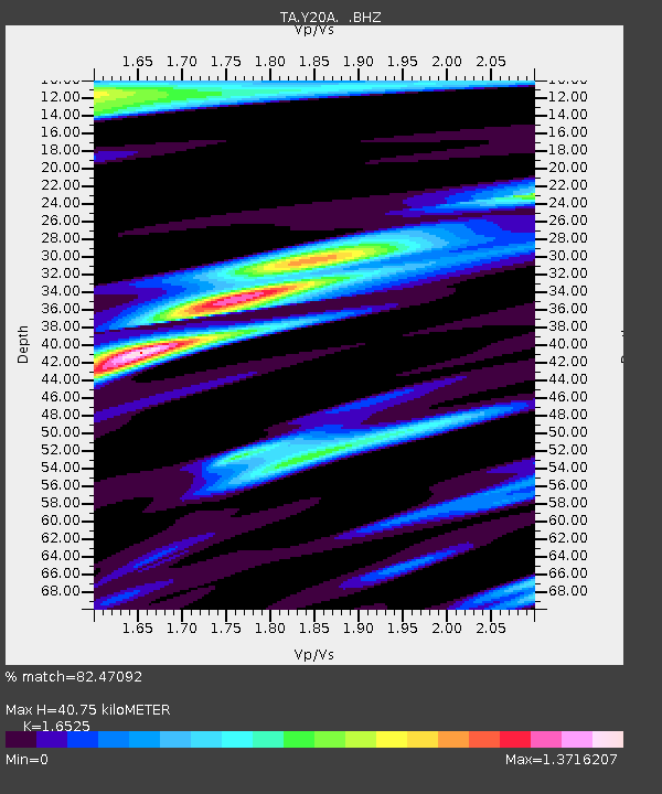
| Estimated Moho Depth: |
40.75 km |
| Estimated Crust Vp/Vs: |
1.65 |
| Assumed Crust Vp: |
6.276 km/s |
| Estimated Crust Vs: |
3.798 km/s |
| Estimated Crust Poisson's Ratio: |
0.21 |
|
| Radial Match: |
82.47092 % |
| Radial Bump: |
400 |
| Transverse Match: |
60.808456 % |
| Transverse Bump: |
400 |
| SOD ConfigId: |
2760 |
| Insert Time: |
2010-03-06 17:20:34.108 +0000 |
| GWidth: |
2.5 |
| Max Bumps: |
400 |
| Tol: |
0.001 |
|

Signal To Noise
| Channel | StoN | STA | LTA |
| TA:Y20A: :BHZ:20090510T01:23:02.923989Z | 3.6083367 | 4.158032E-7 | 1.15234045E-7 |
| TA:Y20A: :BHN:20090510T01:23:02.923989Z | 1.3431858 | 1.8156378E-7 | 1.3517398E-7 |
| TA:Y20A: :BHE:20090510T01:23:02.923989Z | 1.9207076 | 1.267565E-7 | 6.599469E-8 |
| Arrivals |
| Ps | 4.6 SECOND |
| PpPs | 16 SECOND |
| PsPs/PpSs | 21 SECOND |


