You are here: Home > Network List > TA - USArray Transportable Network (new EarthScope stations) Stations List
> Station 435B Jarrell, TX, USA > Earthquake Result Viewer
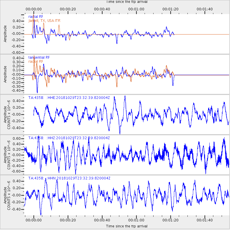
435B Jarrell, TX, USA - Earthquake Result Viewer
*The percent match for this event was below the threshold and hence no stack was calculated.
| Earthquake location: |
Central East Pacific Rise |
| Earthquake latitude/longitude: |
-4.6/-105.9 |
| Earthquake time(UTC): |
2018/10/29 (302) 23:26:09 GMT |
| Earthquake Depth: |
10 km |
| Earthquake Magnitude: |
5.8 Mww |
| Earthquake Catalog/Contributor: |
NEIC PDE/us |
|
| Network: |
TA USArray Transportable Network (new EarthScope stations) |
| Station: |
435B Jarrell, TX, USA |
| Lat/Lon: |
30.78 N/97.58 W |
| Elevation: |
248 m |
|
| Distance: |
36.0 deg |
| Az: |
12.225 deg |
| Baz: |
194.198 deg |
| Ray Param: |
$rayparam |
*The percent match for this event was below the threshold and hence was not used in the summary stack. |
|
| Radial Match: |
63.907272 % |
| Radial Bump: |
400 |
| Transverse Match: |
69.717606 % |
| Transverse Bump: |
348 |
| SOD ConfigId: |
13570011 |
| Insert Time: |
2019-05-01 16:33:41.352 +0000 |
| GWidth: |
2.5 |
| Max Bumps: |
400 |
| Tol: |
0.001 |
|
Signal To Noise
| Channel | StoN | STA | LTA |
| TA:435B: :HHZ:20181029T23:32:39.820004Z | 2.3551097 | 3.3377881E-7 | 1.4172538E-7 |
| TA:435B: :HHN:20181029T23:32:39.820004Z | 1.5241055 | 2.1241847E-7 | 1.3937255E-7 |
| TA:435B: :HHE:20181029T23:32:39.820004Z | 0.81660736 | 1.2057123E-7 | 1.4764896E-7 |
| Arrivals |
| Ps | |
| PpPs | |
| PsPs/PpSs | |


