You are here: Home > Network List > 2H - Interim Broadband Monitoring of the Mount Erebus Volcano Stations List
> Station NAUS Mt Erebus site NAUS > Earthquake Result Viewer
NAUS Mt Erebus site NAUS - Earthquake Result Viewer
| Earthquake location: |
North Island, New Zealand |
| Earthquake latitude/longitude: |
-39.1/175.0 |
| Earthquake time(UTC): |
2018/10/30 (303) 02:13:39 GMT |
| Earthquake Depth: |
227 km |
| Earthquake Magnitude: |
6.1 Mww |
| Earthquake Catalog/Contributor: |
NEIC PDE/us |
|
| Network: |
2H Interim Broadband Monitoring of the Mount Erebus Volcano |
| Station: |
NAUS Mt Erebus site NAUS |
| Lat/Lon: |
77.52 S/167.15 E |
| Elevation: |
3590 m |
|
| Distance: |
38.7 deg |
| Az: |
182.713 deg |
| Baz: |
9.759 deg |
| Ray Param: |
0.074514024 |
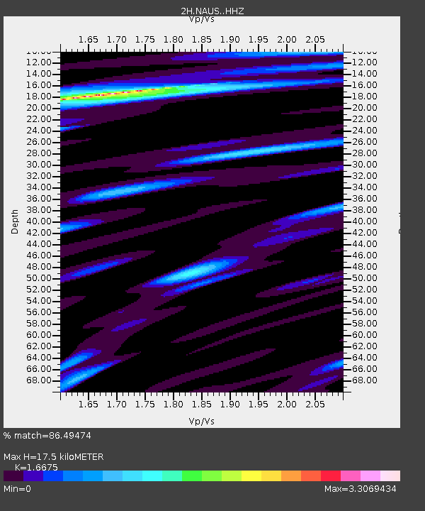
| Estimated Moho Depth: |
17.5 km |
| Estimated Crust Vp/Vs: |
1.67 |
| Assumed Crust Vp: |
6.183 km/s |
| Estimated Crust Vs: |
3.708 km/s |
| Estimated Crust Poisson's Ratio: |
0.22 |
|
| Radial Match: |
86.49474 % |
| Radial Bump: |
400 |
| Transverse Match: |
74.12806 % |
| Transverse Bump: |
400 |
| SOD ConfigId: |
13570011 |
| Insert Time: |
2019-05-01 16:36:39.255 +0000 |
| GWidth: |
2.5 |
| Max Bumps: |
400 |
| Tol: |
0.001 |
|

Signal To Noise
| Channel | StoN | STA | LTA |
| 2H:NAUS: :HHZ:20181030T02:20:11.065015Z | 4.811874 | 7.218803E-7 | 1.5002064E-7 |
| 2H:NAUS: :HH1:20181030T02:20:11.065015Z | 1.8937325 | 5.012889E-7 | 2.6470948E-7 |
| 2H:NAUS: :HH2:20181030T02:20:11.065015Z | 0.86815786 | 1.6694375E-7 | 1.9229654E-7 |
| Arrivals |
| Ps | 2.0 SECOND |
| PpPs | 7.0 SECOND |
| PsPs/PpSs | 9.1 SECOND |


