You are here: Home > Network List > GE - GEOFON Stations List
> Station SNAA GEOFON/AWI Station Sanae, Antarctica > Earthquake Result Viewer
SNAA GEOFON/AWI Station Sanae, Antarctica - Earthquake Result Viewer
| Earthquake location: |
North Island, New Zealand |
| Earthquake latitude/longitude: |
-39.1/175.0 |
| Earthquake time(UTC): |
2018/10/30 (303) 02:13:39 GMT |
| Earthquake Depth: |
227 km |
| Earthquake Magnitude: |
6.1 Mww |
| Earthquake Catalog/Contributor: |
NEIC PDE/us |
|
| Network: |
GE GEOFON |
| Station: |
SNAA GEOFON/AWI Station Sanae, Antarctica |
| Lat/Lon: |
71.67 S/2.84 W |
| Elevation: |
846 m |
|
| Distance: |
69.6 deg |
| Az: |
180.738 deg |
| Baz: |
178.184 deg |
| Ray Param: |
0.054905448 |
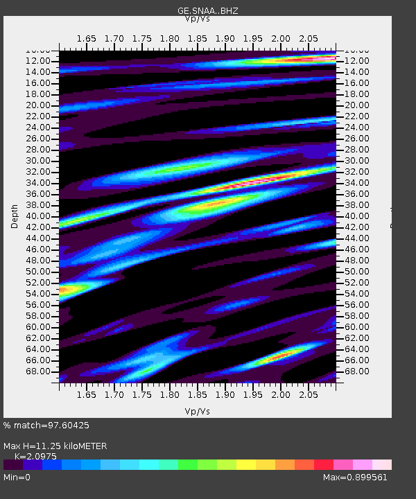
| Estimated Moho Depth: |
11.25 km |
| Estimated Crust Vp/Vs: |
2.10 |
| Assumed Crust Vp: |
6.43 km/s |
| Estimated Crust Vs: |
3.065 km/s |
| Estimated Crust Poisson's Ratio: |
0.35 |
|
| Radial Match: |
97.60425 % |
| Radial Bump: |
384 |
| Transverse Match: |
86.37584 % |
| Transverse Bump: |
400 |
| SOD ConfigId: |
13570011 |
| Insert Time: |
2019-05-01 16:38:56.736 +0000 |
| GWidth: |
2.5 |
| Max Bumps: |
400 |
| Tol: |
0.001 |
|
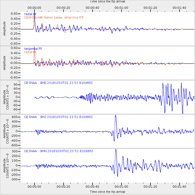
Signal To Noise
| Channel | StoN | STA | LTA |
| GE:SNAA: :BHZ:20181030T02:23:52.810986Z | 7.449987 | 5.074398E-5 | 6.811284E-6 |
| GE:SNAA: :BHN:20181030T02:23:52.810986Z | 4.3182893 | 1.977313E-5 | 4.578926E-6 |
| GE:SNAA: :BHE:20181030T02:23:52.810986Z | 1.7554939 | 6.6512303E-6 | 3.7888085E-6 |
| Arrivals |
| Ps | 2.0 SECOND |
| PpPs | 5.3 SECOND |
| PsPs/PpSs | 7.2 SECOND |


