You are here: Home > Network List > TA - USArray Transportable Network (new EarthScope stations) Stations List
> Station Y20A Horse Springs, Datil, NM, USA > Earthquake Result Viewer
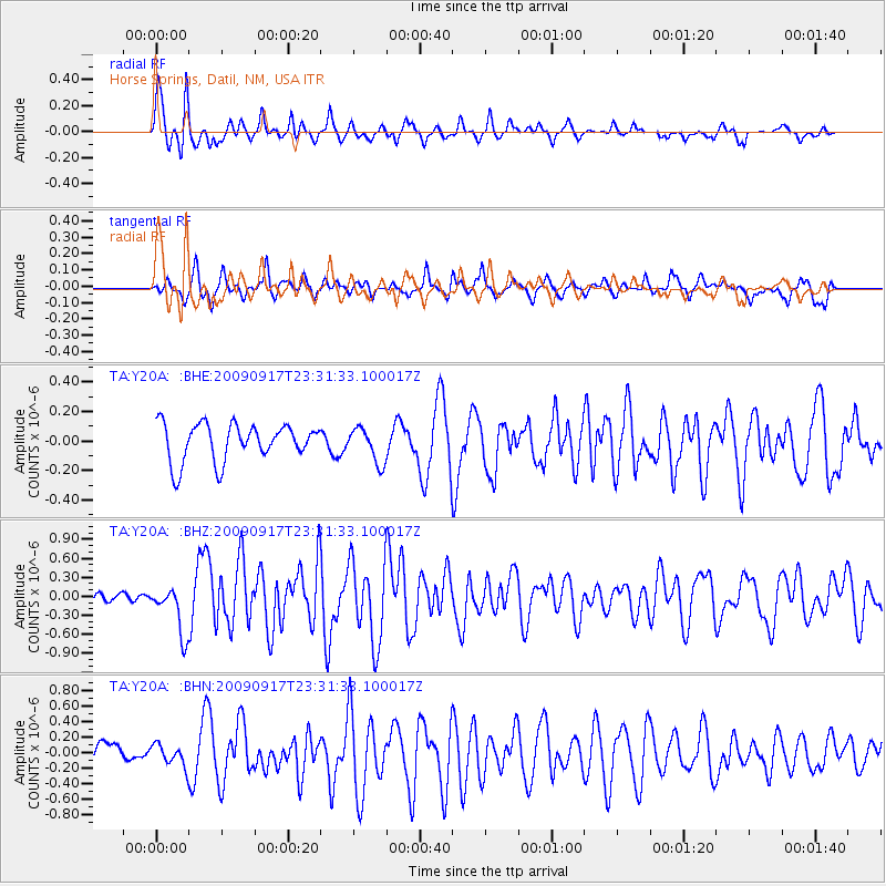
Y20A Horse Springs, Datil, NM, USA - Earthquake Result Viewer
*The percent match for this event was below the threshold and hence no stack was calculated.
| Earthquake location: |
Easter Island Region |
| Earthquake latitude/longitude: |
-29.1/-112.3 |
| Earthquake time(UTC): |
2009/09/17 (260) 23:21:38 GMT |
| Earthquake Depth: |
10 km |
| Earthquake Magnitude: |
5.7 MB, 6.0 MS, 6.2 MW, 6.2 MW |
| Earthquake Catalog/Contributor: |
WHDF/NEIC |
|
| Network: |
TA USArray Transportable Network (new EarthScope stations) |
| Station: |
Y20A Horse Springs, Datil, NM, USA |
| Lat/Lon: |
33.91 N/108.38 W |
| Elevation: |
2177 m |
|
| Distance: |
62.8 deg |
| Az: |
3.637 deg |
| Baz: |
183.825 deg |
| Ray Param: |
$rayparam |
*The percent match for this event was below the threshold and hence was not used in the summary stack. |
|
| Radial Match: |
75.16837 % |
| Radial Bump: |
400 |
| Transverse Match: |
70.19706 % |
| Transverse Bump: |
400 |
| SOD ConfigId: |
2622 |
| Insert Time: |
2010-03-06 17:21:40.979 +0000 |
| GWidth: |
2.5 |
| Max Bumps: |
400 |
| Tol: |
0.001 |
|
Signal To Noise
| Channel | StoN | STA | LTA |
| TA:Y20A: :BHZ:20090917T23:31:33.100017Z | 4.352081 | 3.8230982E-7 | 8.7845294E-8 |
| TA:Y20A: :BHN:20090917T23:31:33.100017Z | 0.86488575 | 1.3459277E-7 | 1.5561913E-7 |
| TA:Y20A: :BHE:20090917T23:31:33.100017Z | 0.93461347 | 1.18127986E-7 | 1.2639234E-7 |
| Arrivals |
| Ps | |
| PpPs | |
| PsPs/PpSs | |


