You are here: Home > Network List > YT07 - POLENET Stations List
> Station THUR THUR > Earthquake Result Viewer
THUR THUR - Earthquake Result Viewer
| Earthquake location: |
North Island, New Zealand |
| Earthquake latitude/longitude: |
-39.1/175.0 |
| Earthquake time(UTC): |
2018/10/30 (303) 02:13:39 GMT |
| Earthquake Depth: |
227 km |
| Earthquake Magnitude: |
6.1 Mww |
| Earthquake Catalog/Contributor: |
NEIC PDE/us |
|
| Network: |
YT POLENET |
| Station: |
THUR THUR |
| Lat/Lon: |
72.53 S/97.56 W |
| Elevation: |
239 m |
|
| Distance: |
52.5 deg |
| Az: |
157.649 deg |
| Baz: |
258.612 deg |
| Ray Param: |
0.06587868 |
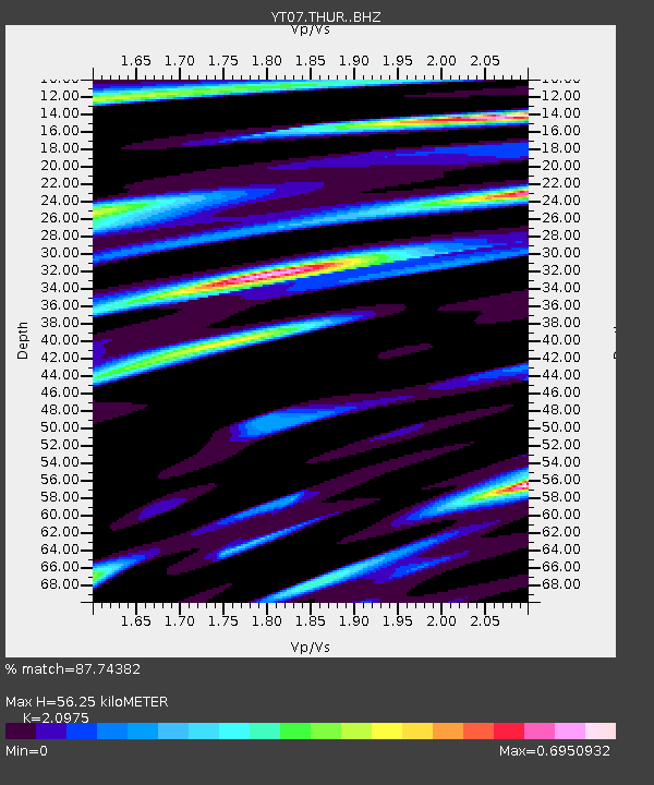
| Estimated Moho Depth: |
56.25 km |
| Estimated Crust Vp/Vs: |
2.10 |
| Assumed Crust Vp: |
6.43 km/s |
| Estimated Crust Vs: |
3.065 km/s |
| Estimated Crust Poisson's Ratio: |
0.35 |
|
| Radial Match: |
87.74382 % |
| Radial Bump: |
365 |
| Transverse Match: |
84.2138 % |
| Transverse Bump: |
390 |
| SOD ConfigId: |
13570011 |
| Insert Time: |
2019-05-01 16:40:02.716 +0000 |
| GWidth: |
2.5 |
| Max Bumps: |
400 |
| Tol: |
0.001 |
|

Signal To Noise
| Channel | StoN | STA | LTA |
| YT:THUR: :BHZ:20181030T02:21:58.625012Z | 4.406154 | 6.6043094E-7 | 1.498883E-7 |
| YT:THUR: :BHN:20181030T02:21:58.625012Z | 1.5713166 | 1.9003204E-7 | 1.209381E-7 |
| YT:THUR: :BHE:20181030T02:21:58.625012Z | 3.709842 | 3.5612481E-7 | 9.599461E-8 |
| Arrivals |
| Ps | 10 SECOND |
| PpPs | 26 SECOND |
| PsPs/PpSs | 36 SECOND |


