You are here: Home > Network List > TA - USArray Transportable Network (new EarthScope stations) Stations List
> Station Y20A Horse Springs, Datil, NM, USA > Earthquake Result Viewer
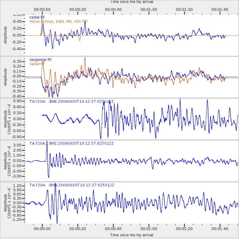
Y20A Horse Springs, Datil, NM, USA - Earthquake Result Viewer
*The percent match for this event was below the threshold and hence no stack was calculated.
| Earthquake location: |
Peru-Bolivia Border Region |
| Earthquake latitude/longitude: |
-15.6/-69.3 |
| Earthquake time(UTC): |
2009/09/30 (273) 19:03:17 GMT |
| Earthquake Depth: |
255 km |
| Earthquake Magnitude: |
5.9 MB, 5.8 MW |
| Earthquake Catalog/Contributor: |
WHDF/NEIC |
|
| Network: |
TA USArray Transportable Network (new EarthScope stations) |
| Station: |
Y20A Horse Springs, Datil, NM, USA |
| Lat/Lon: |
33.91 N/108.38 W |
| Elevation: |
2177 m |
|
| Distance: |
61.7 deg |
| Az: |
323.447 deg |
| Baz: |
136.351 deg |
| Ray Param: |
$rayparam |
*The percent match for this event was below the threshold and hence was not used in the summary stack. |
|
| Radial Match: |
68.17084 % |
| Radial Bump: |
400 |
| Transverse Match: |
56.176155 % |
| Transverse Bump: |
400 |
| SOD ConfigId: |
2622 |
| Insert Time: |
2010-03-06 17:21:43.508 +0000 |
| GWidth: |
2.5 |
| Max Bumps: |
400 |
| Tol: |
0.001 |
|
Signal To Noise
| Channel | StoN | STA | LTA |
| TA:Y20A: :BHZ:20090930T19:12:37.625012Z | 14.659202 | 1.5160783E-6 | 1.0342162E-7 |
| TA:Y20A: :BHN:20090930T19:12:37.625012Z | 3.4134295 | 5.3757424E-7 | 1.57488E-7 |
| TA:Y20A: :BHE:20090930T19:12:37.625012Z | 3.350049 | 4.5996262E-7 | 1.3730026E-7 |
| Arrivals |
| Ps | |
| PpPs | |
| PsPs/PpSs | |


